
3 The Shape of Place: The Lower Pecos Canyonlands as a Chicomoztoc?
Carolyn E. Tate
https://doi.org/10.52713/PGWG7974
“That is the essence of science:
Ask an impertinent question, and you are on the way to a pertinent answer.”
– J. Bronowski, The Ascent of Man, BBC series, 1973
In the Art Appreciation classes he taught at the University of Texas in the mid-1980’s, Terence Grieder often quoted Jacob Bronowski’s insistent focus on open-minded inquiry while dangling his legs off the edge of the stage in the vast lecture hall. By getting physically closer to students, he meant to disarm them, to embolden them to feel excited by the fascinating artworks he showed them each day. By making it clear that “your question is probably more important than your answer,” as he would say, he inspired me, his Teaching Assistant and graduate student, and probably many others whom he captivated, to challenge established ideas and to fear no question. For that reason, questions structure this chapter. They are meant to guide us as we consider how two quite disparate phenomena – Nahua pictography and Archaic rock paintings from the Lower Pecos Canyonlands – might be related.
Could Nahua images of Chicomoztoc, their legendary place of origin, relate to a symbol made 3,000 years earlier and over 1,500 kilometers away in a place that was regarded as primordial even then? This paper looks at toponymic signs as a way to explore possible interaction between Archaic Period pictographs of the Lower Pecos Canyonlands on the Texas – Mexico border (called Pecos River Style pictographs) and several Mesoamerican cultures. While it doesn’t deny the obvious connections between Pecos River Style pictographs and motifs in rock art traditions of the western United States and northwestern Mexico, it aims to share the parallels the author, a Mesoamericanist, sees and to encourage broader contextualization of the Mesoamerican phenomenon. In conducting this far-reaching study, we will explore several cultural moments in which a similar toponymic sign occurred, briefly considering how the new cultural contexts modified the form and meaning of the sign.
When and Where were Mesoamerica’s Early Toponyms?
Toponymic signs were among the first to appear in Mesoamerican pictorial writing and iconographic symbol systems and they occurred among different cultures (Houston 286). Around 150 BCE, signs for conquered places were incised on slabs at Monte Alban. At Teotihuacan, paintings of flowering trees emerging from variable elements like “mask-step” or “yellow platform” served to signal places (Pasztory 161) around 300 CE (Magaloni 175), and toponyms appeared in other contexts as well (Taube 2011; Helmke and Nielsen). It’s possible that earlier, the Olmec people of La Venta used the elongated quincunx as a self-referential place sign (Benson 1971: 29; Tate 186) by around 800 BCE (ibid: 143). Moving to later periods, toponymic signs featured prominently in Mixtec and Nahua manuscripts in the Post-Classic and into the Post-Conquest era.
One of these, the Aztec sign for Chicomoztoc, a primordial place from which the ancestors of Nahuatl speakers emerged, bears a significant resemblance to a sign prominent in the Pecos River Style pictographs of the Lower Pecos region on the modern-day border between Texas and Mexico (Figure 3.1). This study proposes that the pictograph artists of the Lower Pecos region developed a toponymic sign referring to the unusual region called Lower Pecos Canyonlands as early as 1700 BCE (the “crenelated arch”) and continued using it in paintings as late as 400 CE. Additionally, it explores the possibility that Mesoamericans, including the Nahua, journeyed to the Lower Pecos Canyonlands and returned home with memories of a sacred rinconada — a generative place where waters gushed forth, ancestors dwelled in the alcoves of the canyons, and primordial power resided.
How do Mesoamerican toponyms enter into a conversation about the pictographs of the Lower Pecos? Because, although we have scant archaeological evidence of direct contact between Mesoamerican groups and the Lower Pecos, the Gran Chichimeca, the arid region between northern Mesoamerica and the Lower Pecos, was populated by nomadic Uto-Aztecan speakers who could have relayed information to their southern cousins. Furthermore, scholars suspect that Post-Classic Mesoamerican trade routes passed through or near the Lower Pecos. And, tantalizingly, an ancient narrative recorded by Diego Durán suggests that Aztec rulers sought the birthplace of Huitzilopochtli, their tribal deity, in a distant Chicomoztoc beyond the desert.
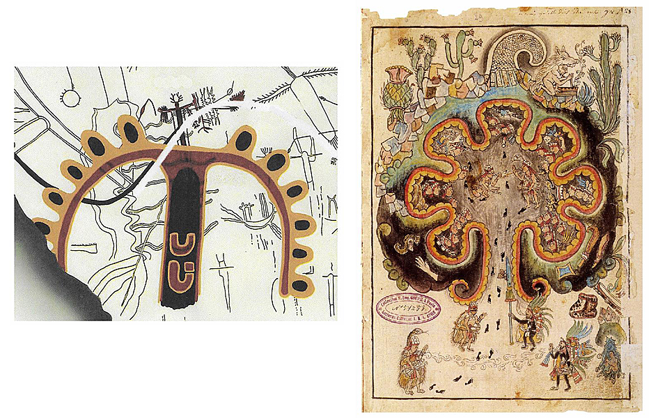
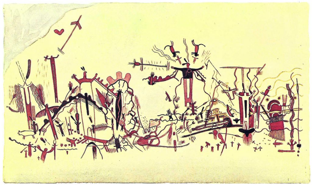
Left: “Crenelated Arch” or the proposed toponymic sign for the Lower Pecos Canyonlands, from White Shaman rockshelter.
Drawing by Carolyn Boyd (2016: Fig. 6.11).
Right: Toltec priests lure the Chichimecs from their caves in Chicomoztoc. Historia Tolteca Chichimeca, f. 16r, ms 51-53.
From Liebsohn 2009.
The Lower Pecos Canyonlands (LPC)
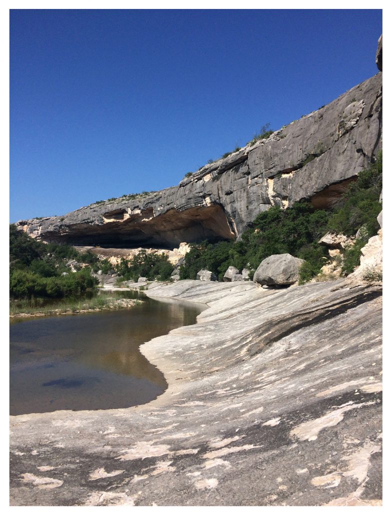
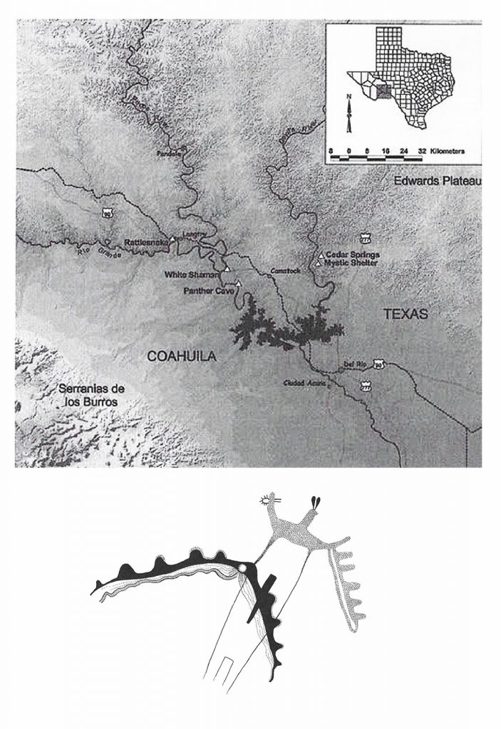
The Lower Pecos Canyonlands is a liminal place (Figure 3.2). Approaching from the north, the steep-sided canyons are hidden as they drop down below the visible terrain. The Pecos and Devils Rivers begin to penetrate the Stockton and Edwards Plateaus in central Texas, gouging the canyons that grow deeper as the river channels empty into the Río Grande / Río Bravo. When rainstorms cross the Plateaus, torrents of water shoot over the cliffs (Figure 3.3). This hydraulic action has carved innumerable rock shelters along the canyon walls. Where these major and smaller seasonal rivers merge into the Río Grande they have created a series of deeply undulating or serpentine bends (Figure 3.4). This series of deep bends in the Río Grande arcs northeastward as the river wraps around a great upthrust, the Serranías del Burro in Coahuila, which are an outlier of the Sierra Madre Oriental.
If one approaches the Canyonlands from northern Mexico, one must contend with the Serranías del Burro, which rises to about 6,000 feet, presenting a formidable barrier. To enter the canyonlands, one would have to go around the mountains or find the passes that thread through the rugged terrain. Once beyond the mountains, a traveler encounters a semi-arid, mostly flat, basin watered by springs that flow northward from the slopes of the Burros toward the Río Grande. Near the springs, however, which one would certainly approach for water, one might find pictographs in dry rockshelters (Turpin 23). On the north side of the Río Grande, the cliffs of the canyonlands rise, and in their river-carved rock shelters are hundreds of pictograph tableaux (Figure 3.5). The region’s biology is as unusual as its terrain. Three different biotic regions – the Tamaulipan Brushlands, the Balconian, and the Trans-Pecos/ Chihuahua desert – overlap in the Canyonlands. Species from each region found that the springs, seeps, and runoff from rain offered conditions conducive to their success. This situation led to an astonishing degree of biological diversity (Blair 93-117; Poole 8-82). In the Lower Pecos Canyonlands, the rivers penetrate the thorny desert, creating a union of opposites. As we can see, the Lower Pecos Canyonlands (LPC) constitutes a peripheral and relatively hidden, semi-arid wonderland of flowing waters and an impressive variety of flora and fauna, including aquatic creatures.
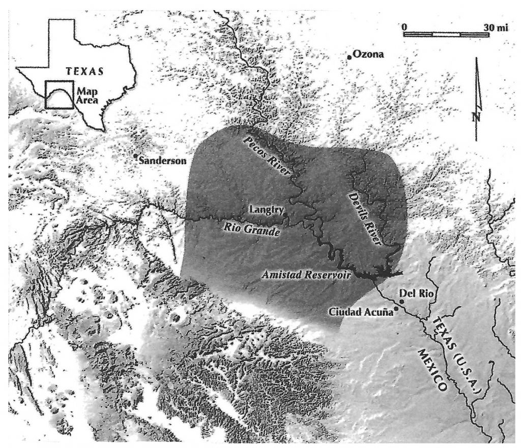
Image courtesy of Shumla Archaeological Research & Education Center.
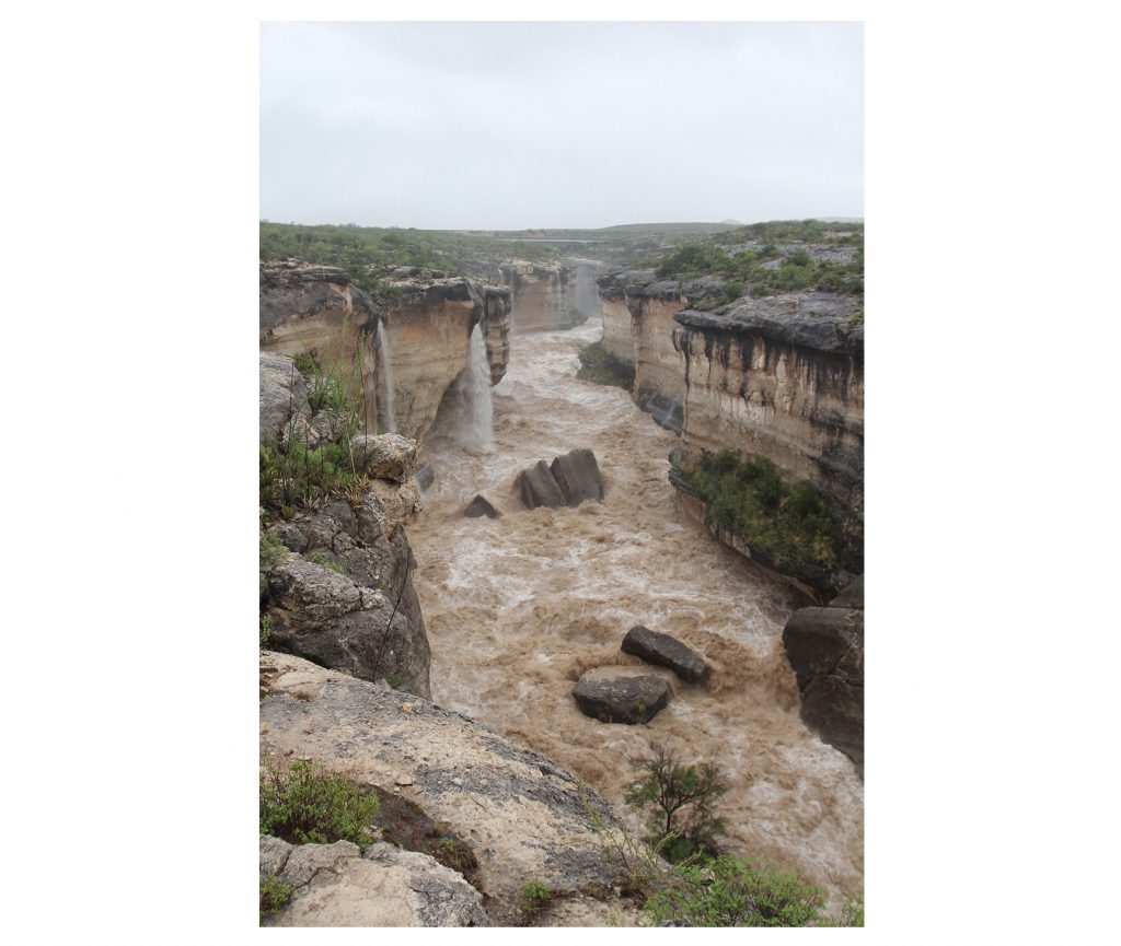
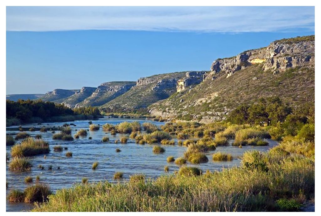
Photo courtesy Tom. W. Stone.
In the 10,000 years that humans have frequented the region, their use of the LPC has fluctuated with the climate. When increased moisture allowed the grasslands of the central United States to extend southward toward the Río Grande River, Paleo-Indians drove bison over the cliffs and butchered them (Prewitt 36). Late Paleo-Indian and Early Archaic bands used the canyons from around 8000 BCE and lived in the rock shelters beginning around 7500-7000 BCE (Shafer 2013a: 30-31). Different groups of humans came and went for thousands of years until the Middle Archaic, around 2100 BCE, when warm, dry conditions on the plains sent people to the relative oases of the canyonlands and the rivers (Ibid. 74). Beginning in the Middle Archaic and continuing into the Historic Period, humans used this region as a locale for pictographs at different times, producing them in several “styles.” Based on both overlapping of paintings and radiocarbon dating, the “Pecos River Style” (Kirkland and Newcomb 37) is the most ancient, produced from around 2300 BCE to 400 CE (Boyd 2016: 24-26). Chemists at Texas A&M (Russ et al. 710-711) developed a radiocarbon dating method specifically for analyzing the organic binders that carried the inorganic pigments used at Pecos River Style sites.
Their closest stylistic affiliations are with the Barrier Canyon pictographs in Utah (Shaafsma 61-72), Abstract Style Petroglyphs of the Chihuahua Desert (Ibid: 43-47), and Archaic pictographs in Baja California. Dates for Barrier Canyon style pictographs, with their elongated anthropomorphic figures, are still disputed and many have argued that they date from the Archaic period. Recent studies refute this and suggest a range of 1 – 1100 CE (Pederson et al. 12986-12981), so consensus is lacking. They were probably made by Northern Uto-Aztecan speakers, who are known to have traveled through this area. Also, at least one of the Abstract Style Petroglyph sites of the Chihuahua Desert, Tres Ojos, which is west of the LPC and near the city of Chihuahua, contains zigzag or undulating lines. These are slightly less complex than the PRS crenelated arch and do not usually involve the emergence of an anthropomorphic figure from an arch. However, they were probably made by Archaic period hunter-gatherers, who frequently situated the petroglyphs near springs and near mountains where food sources were more varied than in the desert plains (Schaafsma 44-47). Until further scientific dating resolves the debate, Pecos River Style pictographs are as early as or predate any major body of paintings elsewhere in North America, including Mesoamerica.
Over thirty-five Pecos River Style (PRS) pictograph sites have been found among the Serranías and, on the Texas side of the border, over 320 rock shelters with PRS pictographs have been documented. Together, these form one of the most extensive corpuses of pictographs surviving in North America. There are complex painted compositions ranging in size from a few painted figures in a small alcove to rock panels measuring over 100 feet (30.5 meters) in width and 30 feet (9.1 meters) in height, populated with hundreds of figures (Kirkland and Newcomb 31; Boyd 2013: 182).
Around 1965, Terence Grieder responded to the imminent threat of flooding of the Pecos River Style pictographs as the Amistad Dam was planned. He and David Gebhard of the University of California at Santa Barbara served on the Texas Archaeological Salvage Project, administered through the University of Texas under contract with the National Park Service. Grieder undertook a study of pictographs at forty sites and published “Periods in Pecos Style Pictographs” (1966: 710-720) based on an analysis of twelve sites. Grieder suggested that as the climate changed, the economy of those living around the Pecos River shifted from a reliance on fishing to a focus on deer hunting on the plateaus. The criteria that Grieder used to determine the order in which paint was applied at a given mural included overlapping of figures and fading of paint.
Since 1998, Shumla Archaeological Research & Education Center has used advanced technology to document these sites before the pictographs disappear. By using digital microscopy to analyze the overlapping of paint layers, portable X-ray fluorescence spectroscopy to determine the elemental composition of the paints, and 14C Plasma oxidation to refine the dates at which the paintings were made, Shumla has greatly improved the reliability of Pecos River Style chronology since Grieder’s time. Instead of the shift in subject matter and style that Grieder proposed, what has emerged is a surprising consistency of style over two millennia. Some subject matter also persisted; certainly further research will find meaningful variation in subject matter over time.
The Pecos River Style (PRS)
Although Grieder called the PRS imagery “abstract” (1996:324), it was based on knowledge of human and animal forms, so perhaps it should be called “stylized.” Across hundreds of rock shelters, and probably two thousand years, artists worked in a consistent mode of representation (Figure 3.6).
All PRS anthropomorphic figures are composed of simple, elongated shapes that make no effort to represent anatomy accurately. Their consistently frontal torsos are usually slightly broader at the top, where outstretched, stick-like arms were attached, and taper toward the bottom. Simple, linear legs hang below the elongated torso. Heads may be frontal or profile, are often small relative to the torso, and mostly lack facial features. Despite these similarities, anthropomorphic figures are far from identical. The colors and patterns that decorate the interiors of the torsos differ, although in many compositions, similar figures appear, such as at White Shaman, where a black-torso figure with a red top or head repeats five times across the mural (Boyd 2016: Fig. 5.11). Most quadrupeds are shown in profile. Their stick-like legs sprang from simply-shaped bodies, to which are attached identifying elements such as horns or long tails. Compositions generally ignore indications of a tangible earth surface, such as a groundline.
Because these basic forms (elongated torsos) and principles (such as lack of groundline) were so consistent at sites throughout the Lower Pecos it is reasonable to claim that – at least to some extent — they were “conventionalized;” by which I mean that in their choice of shape, color, interior patterning, accoutrements like feathers or rabbit ears, and position relative to other figures within a composition, painters made decisions that conveyed agreed-upon meanings. This degree of intentionality in PRS pictographs is made more evident by the recent discovery made by archaeologist Carolyn Boyd (2016: 37-45) that the White Shaman panel, which measures about 26 feet wide and 13 feet high, was conceived as a single composition. She supports this claim with evidence from digital microscopy that each of the four colors found in the mural was painted separately. First, three layers of black, including dissociated dots and lines as well as interior decoration of future figures, were painted across the shelter panel. Following this event, the painter applied red paint in five layers, yellow in two layers, and white in two layers. In other words, individual figures or forms were not painted as a unit. While there may not have been a complete “cartoon” of the final image – a drawing on the earth or maybe deer hide (the binder for the pigments at White Shaman was deer bone marrow) — there must have been some pre-conception of the images that would emerge from this layered application of paint. And, although studies are not yet complete, a similar color-layering process seems to have occurred at some other sites (Boyd, personal communication). The point of this discussion of style is that the PRS pictographs were not randomly conceived or drawn. Artists adhered to a system of image-making. Several design units, or “motifs” within that system (Boyd 2003: 45-81) seem to have been conventionalized symbols.
From Kirkland 1967: Plate 1.
Crenelated Arch: a Toponymic Sign
Among the vast corpus of PRS pictographs that have been documented are several recurring “motifs” which appear at multiple sites. Boyd (ibid. 41) defines “motif” as a repeated image composed of more than one element. One of these is the “crenelated arch” (ibid 41-42, 45-66; 2016: 67–70). This consists of an undulating line, enhanced by lines, dots, or protrusions, which creates an arcing shape (Figure 3.7). Often there is a circular void at the apex of the arch. In all cases there is an anthropomorphic figure with animal attributes that seems to be in the process of passing through the arch.
In her earlier work, Boyd (2003: 49-54) saw the undulating line as a serpent, a symbol for the earth surface, and generally discussed a shamanic context for the PRS pictographs. From that viewpoint, the anthropomorphic figure passes through a portal, for the purpose of contacting spirits or ancestors as helpers. Evidence for the “serpent-portal” comes from Huichol and Yaqui traditions, in which the serpent serves as the gateway to the world below. In a later work that focuses on the White Shaman site, which may date to as late as the first centuries CE, Boyd (2016: 67-74) draws further analogies with Huichol oral tradition, proposing that this crenelated arch corresponds to the Huichol Dawn Mountain, “the flowered destination of the pilgrims as they pursue the deer through the underworld” (Ibid. 69). At Dawn Mountain, ancestors emerged, the deer sacrificed themselves so that the sun could dawn, and so both sun and its analog peyote were born there. More generally, she considers the crenelated arch motif to refer to the “prototypical primordial mountain, the location from which all life emerged” (ibid 69).
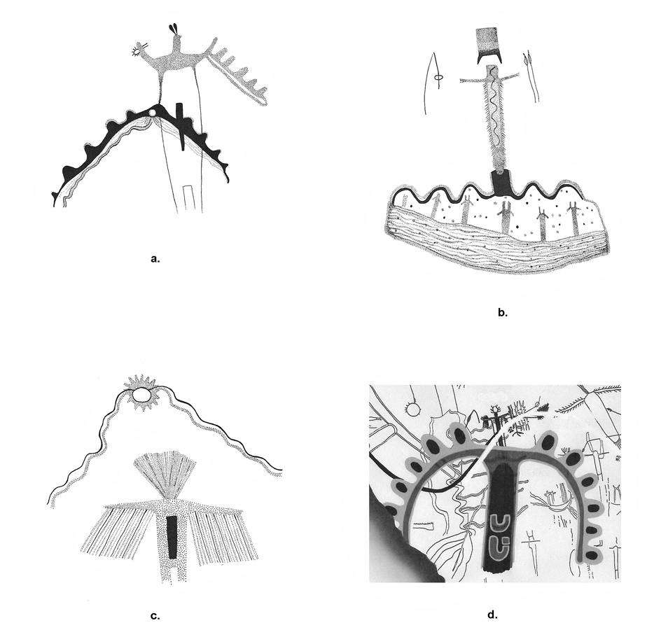
a. Rattlesnake Canyon (from Boyd 2003)
b. Mystic Shelter (from Boyd 2003)
c. Rattlesnake Canyon (from Boyd 2003)
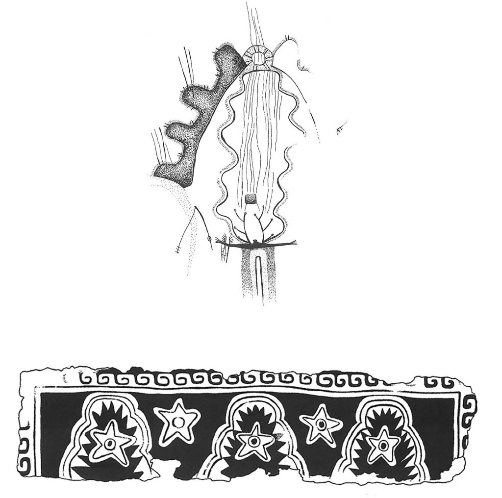
d. White Shaman Shelter (from Boyd 2016: Fig. 6.11)
Because the crenelated arch is a recurring, recognizable component of PRS art but does not appear as a “motif” (an undulating line plus a consistent additional element) in known rock art at Archaic period sites in northern Mexico or the southwestern United States, I propose that in addition to the possible meanings derived from analogies with the beliefs of the Huichol and Nahua, it is an early example of a toponymic sign, a conventionalized sign that refers to the overall character of the Lower Pecos Canyonlands. Figure 3.8 shows the current courses of the Pecos, Devils and Río Grande near their confluences. Note that the Río Grande arches northward as it wraps around the Serranías del Burro, which perhaps led to the use of the arcing shape of the toponymic sign. Nowhere else along the Río Grande are the bends as deep as in this region, and the Pecos and Devils also follow extreme switchbacks.
In the polyvalent way that many symbols function, the arch’s undulating shapes may refer to both a primordial mountain, perhaps to the Serranías, and to the bends of the Río Grande, Pecos, and Devil’s Rivers which supported the abundant life forms of the region. The pronounced undulations of the three rivers imbued the region with serpentine qualities, especially the snake’s ambivalent but powerful abilities to kill others and regenerate itself. The anthropomorphic figure that passes through the arch arises from the rivers and canyons as either an ancestor or as part of shamanic activity.
What we are seeing in the development of a toponymic sign by 2000 BCE may be a phase in the development of a semasiographic communication system. Semasiographic symbols communicate information directly to a viewer and do not depend on language. As discussed by art historian Elizabeth Boone (2000: 30-31), images in such a system visually evoke the referent. In this case, the referent is the hidden rincón of the Lower Pecos region, its undulating arcs of canyons through which water explodes, creating a basin bordered by mountains and filled with a diversity of life forms, which bore evidence of very ancient human use and occupation. We will return to the importance of the rincón in a later section.
Map courtesy of Shumla Archaeological Research & Education Center; crenelated arch from Boyd 2003.
I do not claim that Pecos River Style pictographs are “writing,” because most of the imagery is neither as consistent nor as fully developed as Central Mexican pictography. Instead, I merely suggest that the crenelated arch motif is a toponym. These, however, were among the types of signs to emerge when pictorial writing systems did develop in Mesoamerica.
How Have Scholars Identified Toponymic Signs?
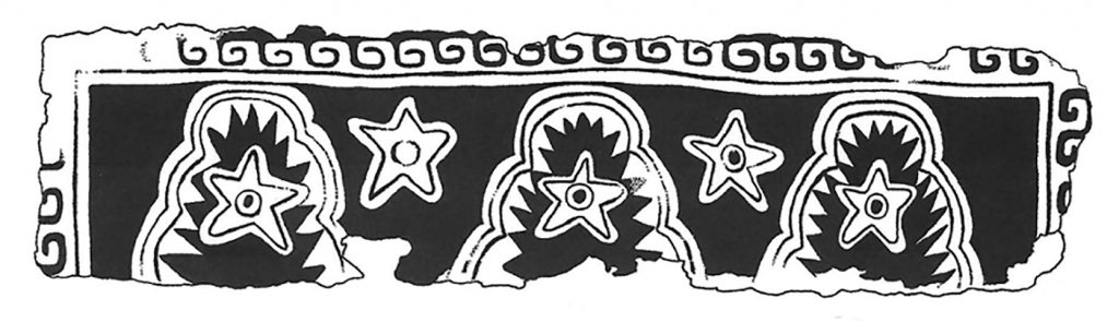
In the 1970’s, several scholars recognized the presence of toponyms in Mesoamerican art and pictorial writing. Examining the murals of Teotihuacan, archaeologist Jorge Angulo (50–51) suggested that the repeated motif of a scalloped arch enclosing an interior border of serrated shapes was a sign for mountain and served as part of a toponym (Figure 3.9). This image appeared in multiples along the lower portion of the walls in Room 13 of Zone 5-A, a building along the northwest side of the Avenue of the Dead.
Mary Elizabeth Smith’s pioneering study of Mixtec place signs clarified that they consist of a “geographic substantive” which is a sign referring to a feature such as a town, irrigated plain, hill, or river (Smith 38-42). This is modified by the addition of a “qualifier,” which could be a color, animal, ritual object, or other item that designates a specific feature (Figure 3.10). Some toponymic signs, especially Aztec ones, included phonetic elements, but because of their pictorial nature, they could often be read by different speech communities (Boone 51). From this brief overview, we glean that early Mesoamerican toponymic signs usually consisted of more than one element; they may appear in multiples in a single composition; that similar toponymic signs may occur at different locations within a cultural zone; and that the emphasis on pictorial rather than phonetic elements in early signs made it more likely that speakers of different languages could understand them. These are all characteristics of the PRS crenelated arch.
From Helmke and Nielsen 2014.
Left: Zahuatlán or Yucu Nicata (Hill That Danced).
Right: Magdalena Jaltepec or Añute (Place of Sand).
Images from Boone 2000: Fig. 24.
What Kinds of Places Have Toponymic Signs Referred To?
In the toponym in Figure 3.9, the scalloped arch referred to a mountain and the five-pointed star within and beside the three mountain images named it as “Star Mountain” (Helmke and Nielsen 85-91). Signs for Star Mountain occurred in several different locations at Teotihuacan. Christophe Helmke and Jesper Nielsen (ibid) use 17th century documentary evidence to suggest that the hill to which the sign refers lies about six kilometers north of the Moon Pyramid. This “Star Mountain” mural is in a room in which another mural portrays a mythical event, the shooting of a celestial bird by blowgunners, and Helmke and Nielsen (ibid.) suggest that the two “Star Mountain” murals in the room indicate where the mythical event occurred, perhaps at Citlaltepetl, Star Mountain, Mexico’s highest peak, now called Orizaba. In addition to referring to actual places, such as the local and distant Star Mountains, toponymic signs at Teotihuacan can also refer to supernatural ones, like Flower Mountain, a primordial place of abundance and one to which the souls of warriors returned (Taube 2006: 153-170).
Around 150 BCE, Zapotecs developed toponymic signs to represent conquered places. These appear on the Conquest Slabs of Monte Alban during Period II (Caso 938). By the Post-Classic, of course, toponymic signs helped the Mixtec convey narratives of genealogy, conquest, and ritual in their pictorial histories. One mythic place the Mixtecs referred to (in the Codex Vienna Obverse) was Chicomoztoc, a place of ancestral origins. Similarly, the PRS crenelated arch and the anthropomorph that passes through it probably refer to a place that exists but was thought to possess supernatural qualities; a primordial place of ancestral or shamanic emergence. Like the Teotihuacan example, the crenelated arch can occur multiple times in a single composition.
Comparing Toponymic Signs
Figure 3.11 compares a Middle Archaic crenelated arch from Cedar Springs to the Early Classic “Star Mountain” toponymic sign from Teotihuacan. The exterior lobes of the PRS crenelated arch are black on the left and white on the right, with a central opening decorated with stripes. A double-outline undulating form drapes within both sides of the arch. Within or behind this are faint lines that seem to flow from above the opening to the antlered anthropomorphic figure below, who reaches toward hunting tools. The Teotihuacan example shares an elongated undulating arch with interior jagged crenelations. The purpose of this comparison is twofold – to consider the similar forms of the two toponyms and to show that toponymic signs may refer to both physical and mythical places.
Figure 3.12 also compares Mesoamerican mountain motifs, including one toponym, to two PRS crenelated arch images. The arch motif at Mystic Shelter (Figure 3.12a) is located slightly left of the painting’s center. We can see the snakelike line of the undulating earth surface or the river. In this case, the anthropomorph, who is associated with an atlatl and dart points, emerges through a black hole. The crenelated arch seems to surround an alternate realm of smaller anthropomorphs surrounded by black and red dots.
Figure 3.12c shows one of three crenelated arches from Rattlesnake Canyon, one of the earlier sites, radiocarbon dated between 2000 and 1700 BC. The 106-foot wide (Boyd 2016: 21) painted panel at Rattlesnake Canyon is tucked into a large grotto within fifty meters of the Río Grande. The undulating lobes are painted black with a red outline. Like many arches, this one has an aperture near the top and a paler membrane of undulating red and black lines within the arch echoes its shape. More than many, this early arch and its membrane suggest the canyons along the Río Grande (the black lobes) and the river itself (the “membrane”).
Figure 3.12b is a drawing of a large stela from the Gulf Coast Olmec site of La Venta. It probably dates to the end of the Olmec era, about 600 – 400 BCE (Tate 208). The frontal face on this stela is a stylized image of the human embryo, bundled in three intra-uterine sacs (represented by three bands below the face) and a maize seed headband (directly above the face; ibid. 38–45; 208–211; or for alternative interpretations see Schele 105-117 and Taube, 1996: 39-81). With the triple maize sprouts emerging from the apex of the image, this combination of human embryo and maize symbols is an early example of the southern Mesoamerican metaphor “humans are maize,” which originated in the Middle Formative Period (Tate 58), after humans transformed tiny cobs of maize into larger ones and it became a useful crop (Rust and Leyden 181-201; Pope et.al. 1370-1373). The crown of the embryo’s head takes the form of deeply undulating lobes similar to those in the crenelated arches. Interestingly, the lobed head on this image has been called a mountain (Grove 255-300). The maize sprouts from this sign for mountain. This is one of four green schist stelae carved with the human embryo-maize image that stood at the southern foot of the large earthen mound at La Venta, marking it as a “Mountain of Sustenance” or “Flower Mountain,” a primordial, mythical place.
Figure 3.12d shows a Teotihuacan toponym for “Flower Mountain,” a mythic primordial location of abundance for deceased Teotihuacan warriors (Helmke and Nielsen 83-84). The Flower Mountain toponym consistently possesses three peaks. The purpose of this comparison is to show that Middle Formative and Early Classic Mesoamerican graphic communication systems used similar ways of stylizing the concept of mountain and that these also bear some resemblance to the crenelated arch toponym in the Pecos River Style, and, further, that all three seem to refer to a primordial place of abundance. Pecos River Style pictographs gradually filled the grottoes of the Lower Pecos Canyonlands between about 2000 BCE and 600 CE (Boyd 2016: 25-26), suggesting that the region was probably a sacred destination for hunter-gatherer groups of arid North America.
Upper: Proposed toponymic sign from Cedar Springs site.
From Boyd 2003.
Lower: “Star Mountain” mural (cf. Figure 3.9).
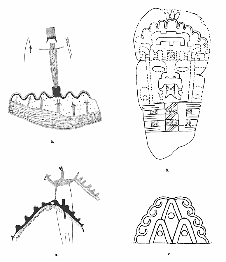
a. Mystic Shelter (cf. Figure 7b.)
b. Olmec Monument (Stela) 25/26, La Venta, Mexico, c.1000-700 BCE, showing a bundled embryo’s co-identification with maize, which sprouts from a “mountain” sign. Drawing by Carolyn Tate.
c. Rattlesnake Canyon (cf. Figure 7a.)
d. Teotihuacan “Flower Mountain” sign, c. 400-600 CE. From Helmke and Neilsen 2014.
Could Mesoamericans, at Various Times, Have Visited the Lower Pecos Canyonlands?
Nahua pictorial manuscripts and early Colonial texts from Central Mexico document several instances in which Nahuatl speakers journeyed from their place to other places, in search of the primordial place, Chicomoztoc, which means “Place of Seven Caves.” There are many representations of Chicomoztoc; space limits this discussion to a few.
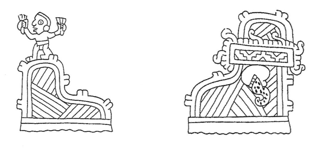
Figure 3.1 includes a portrayal of Chicomoztoc from the Historia Tolteca Chichimeca, a bound manuscript from Cuauhtinchan, Puebla (1545-63; Liebsohn 38). The seven caves surround a vaginal opening which is penetrated by the Toltec Quetzaltehueyac’s spear as he summons the Chichimecs within the caves. Red and orange paint outline the deeply lobed shapes of the seven caves and the interior of the womb-like shape is lined with smaller undulating bulges, which by the Post-Classic signify internal tissue, in this case, the lining of the womb (Milbrath 155). Within the lobes of the cave are multiple heads representing clans of Chichimecs, each named except for the lobe containing four women. Above the cave sign is the curled hill signifying Colhuatepec, Place of Those With Ancestors (Boone 37). The dark color surrounding the cave is marked by the curlicue signs for stone and as the underground transitions to the earth surface, plants are shown growing from rocks. These are thorny desert plants found in the Chihuahua Desert Biotic zone, which extends into the Lower Pecos. At the lower right corner of the image, a cave gives birth to a child, its water bursting forth. This specifies that Chicomoztoc is a place of gushing, life-giving waters, where humans emerged.
Figure 3.1 compares this image to the latest crenelated arch in Pecos River Style, the one from White Shaman Cave (Boyd 2016: Fig. 5.6), for which radiocarbon dates provide a mean and standard deviation of 2000 +/- 400 RCYBP, or about 400 BCE – 400 CE (ibid. 26). In this late version of the Lower Pecos toponym, the arch takes a more regular shape with six lobes on each side of a central vertical passageway, painted black with red and yellow outlines. The arch and lobes are painted with yellow and red bands and with black ovals within each lobe, much like the Chicomoztoc cave. U-shaped signs adorn the black central passageway, which I suggest refer, like their Olmec counterparts, to the womb (Tate 222-227). An antlered anthropomorph grasping ritual paraphernalia emerges from within the arch.
The Chicomoztoc image and the facing page from the Historia record, in Nahuatl alphabetic text and pictures, depicts a journey to Chicomoztoc, taken between 900 and 1200 CE, when the rule of the Tolteca-Chichimeca in Cholula had been challenged by a confederation of smaller polities. Their patron deity advised them to seek out their ancestors, the great Chichimec warriors of Chicomoztoc, to help them fight for their authority to rule (Liebsohn 33 – 35). Two Tolteca-Chichimeca priests set out from Cholula for Chicomoztoc. After arriving, they performed rituals and made entreaties to the ancestral Chichimec, who remained inside Chicomoztoc. An interpreter emerged and negotiated the aid requested. Many Chichimecs grabbed their bows and arrows. This is of interest because the recurved bow and arrow are found in the Lower Pecos somewhere between 900 and 1200 CE (Shafer 2013b: 84; Boyd 2013: 191) and subsequently introduced to Mexico. These Chichimecs returned with the priests to Cholula.
Nahuatl speakers claimed that their Chichimec ancestors emerged from Aztlan / Chicomoztoc at the behest of their tribal deity, Huitzilopochtli (Hummingbird on the South). Sixteenth-century Friar Diego Durán recorded that in 1441, when Motecuhzoma I reigned as emperor, the origin place of the Mexica, Chicomoztoc, was already lost (Duran 1994). The emperor told his prime minister, Tlacaelel, that he wanted to send a party of warriors to seek out the place their ancestors had lived and to honor Coatlicue, the mother of Huitzilopochtli. Tlacaelel replied that the mission should be staffed not by warriors but by wizards, who could use enchantments to discover the place. It is a great hill in the midst of lagoons filled with reeds and rushes, where the ancestors had lived for many years, he said, cultivating crops and traveling in canoes. It will be covered by thorny bushes, and difficult to find. The wizards first went to Snake Mountain, where they transformed into animals for the rest of their journey. Arriving in Chicomoztoc they found an amazing abundance and variety of fish, plants, and animals. The ancient earth mother, Coatlicue, told them their rich foods and fancy lifestyle had shortened their life span, for here in Chicomoztoc, people did not grow old (Durán 212 – 222). These accounts show that Chicomoztoc was considered a faraway, hidden location. Although it was near water and had a great variety of life forms, it was a thorny desert.
Evidence has been mounting that the peoples of the American Southwest interacted with Mesoamerica-related groups. Archaeologist Stephen Lekson, for example, considers the hierarchical settlement pattern of Chaco Canyon in northwestern New Mexico to relate to the Nahua altepetl (Lekson 8-9; Toner 26-32). Art historian James Farmer (135) suggests that the use of Mesoamerican symbols like feathered serpents and goggle eyes in rock art traditions in the Southwest points to a “conscious choice” to participate in a greater Mesoamerican interaction sphere – and that this began at a very early period.
For me, the question becomes “what kind of mental image would the Nahua have created to encapsulate the qualities of Lower Pecos Canyonlands?”. Amidst the desert is a hidden zone of flowing water and deep canyons. Within the canyons are hundreds of rock shelters crammed with images of floating anthropomorphic beings and their hunter-gatherer tools. Ancient projectile points lie near bison bones in several corners of these canyons. With its diverse life forms, it was a place of primordial abundance from which the ancestors emerged. How would a Nahuatl speaker portray such a place?
The Lower Pecos Canyonlands as a Primordial Rincón
The Nahua tied both dates and movements to places, not to space. This emphasis on movement as being from place to place is vividly shown in their cartographic histories in which paths, sometimes populated, meander among place signs (Boone 162-196). Movement and place are fundamental aspects of Aztec thought, according to philosopher James Maffie. He emphasizes that the Western concept of space as timeless, neutral, and abstract, does not fit the Aztec concept, which is better understood as place. Place, he writes:
“…is a[n] … intricate web of interrelationships between humans, plants, animals, mountains, waters, and sun – all of which are animated and charged with power….[P]lace…situates things within a unique environment rather than within uniform space,” (Maffie 2014: 421).
How did places and people choose each other? Working with 16th-century documents and land titles, art historian Ángel García Zambrano has studied the specific configurations of landscape in which the Nahua founded settlements. The most important geomorphological configuration was the cove or rincón. This was a concave, water-filled basin surrounded by cliffs that were sliced through with ravines in which, ideally, were caves or rock shelters. Where there was a confluence of waterways, the resulting serpentine undulations of the gushing rivers created the mental image of a generative womb. Also, the rincón was hard to reach; one often passed through a narrow ravine or riverbed to find it. García Zambrano writes: “So, whenever indigenous groups embarked on journeys to explore the land in search of a new place to live, they established themselves only in sites that bore specific geomorphological features” (García Zambrano 2007:193). García Zambrano sees the choice of such a rincón as a meta-reference to the mythical Chicomoztoc. Or was Chicomoztoc mythical? Instead, maybe it was ancient and far away. All the features of the rincón can be seen in the Lower Pecos Canyonlands. García Zambrano’s work is informed by Pascal Boyer’s influential descriptions of how humans create meta-representations. García Zambrano writes that in creating place signs or toponyms, the Nahua constructed a mental image of a landscape in which mythic events occurred. Prime among such events was when humans and/or supernaturals emerged through a rincón (García Zambrano, 2015: 923). After emerging through the uterine watery canyons at Chicomoztoc, humans began populating the earth through migration (García Zambrano 2007: 198).
Having provided some evidence that suggests that Mesoamericans of various eras had some knowledge, direct or indirect, of the Lower Pecos and its pictographic record, here I will speculate on some ways they might have obtained it.
Possibilities
It is possible that by 1700 BCE, the people who created Pecos River Style pictographs revered this landscape — populated by the remains of ancestors — as a place of generation, of human origins. I suggest that they devised the “crenelated arch” as a toponymic sign that referred to the generative undulating womb-like canyons and waterways through which ancestors, plants, and animals emerged. Between 600 and 1200 CE, the semi-nomadic groups in Mexico’s far north (Braniff 32-37) who encountered the Lower Pecos may have created a mental representation of this rincón, a place of abundant life and many caves, as one of their places of origin, and retained in their memories and stories, and perhaps even in drawings, this meta-representation as they migrated southward into Central Mexico. In the Late Post-Classic, if Motecuhzoma I did send a search party northward, and if the Tolteca-Chichimeca of Cuauhtinchan did the same, one of the Chicomoztocs they found could have been the Lower Pecos, where they would have seen the rincón and its toponym and adapted the ancient sign to create their own toponym.
Finally, supporting the connection between the Lower Pecos region and Mexico is a DNA study, published in abstract form in 2018, that finds that human remains from the Pecos River style pictograph region are “most closely related to present-day indigenous populations in Mexico, with affinities to contemporary South Americans as well” (Raff, et.al. 217-218). For decades, the late archaeologist Beatríz Braniff proposed that the U.S. Southwest and northern Mexico are part of the “Gran Chichimeca” – the territories of the nomadic ethnic groups of the arid lands. In this region, people often inscribed petroglyphs in the places they passed through for ritual or economic purposes. Figure 3.13 is a 2006 reconstruction of trade routes throughout the Gran Chichimeca (Fournier 28). There is tentative evidence now for a route that intersects the Lower Pecos. These maps show that either Nahua were traveling through the region or were in communication with those who did.
When we think of what leads people from place to place, we should not forget the pathways created by plants and animals, such as peyote, which draws the Huichol into the arid north (Terry); the monarch butterfly, which passes directly over the Lower Pecos; and the ruby-throated hummingbird, like Huitzilopochtli, whose migrations also lead them over the water-filled LPC. Even people walking along the trade routes running west of the Sierra Madre might follow these valiant creatures to the rincón of the Lower Pecos, a place of human origins.
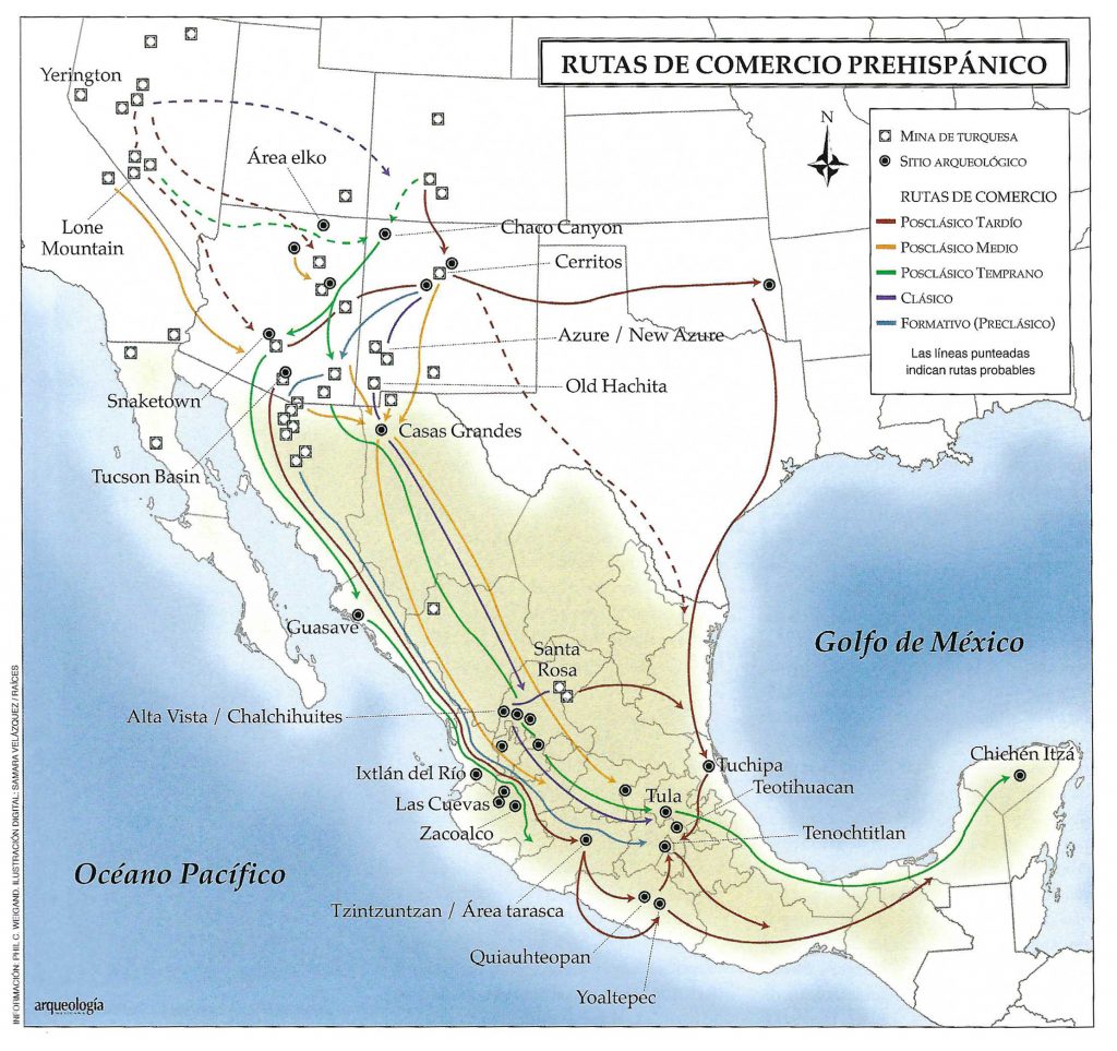
From Fournier 2006: 28.
Conclusions
This study has briefly examined the use of toponymic signs in greater Mesoamerica from 1700 BCE to 1550 CE. Tracking some of the occurrences of the undulating or lobed line as a “mountain” or “earth surface” symbol provides a thread of continuity, a “solid nucleus” as Alfredo López-Austin (1993:304) has termed it. Within each culture, however, the sign carried a distinct significance. For the Pecos River Style people, I think it referred to the combination of cliffs and canyons through which water flowed as a place of abundance and ancestral origins. When the Olmec placed this undulating mountain on the head of a human-maize seed, then showed the seed sprouting, and placed four such monuments at the foot of a human-made mountain, they referred to a Mountain of Abundance, reflecting the concerns of the new lifestyle of maize agriculture that they had recently adopted. In Teotihuacan, surrounded by the mountainous landscape, the sign was adapted to form a variety of specific place names, both real and mythical. The Post-Classic Mixtec and Nahua used the undulating arc to create a toponym for a place of origins, Chicomoztoc.
Although scholars have proposed several possible locations for Chicomoztoc, including Teotihuacan and La Quemada (for example, see Hers 48-53), the Lower Pecos is another possibility. Clearly it was a place of extreme antiquity, filled with images of ancestors or mythical beings, with many cave-like rockshelters, a great variety of life forms, and life-giving, gushing waters. Middle Archaic people who frequented it may have developed the toponymic sign that remained in the memories of the pilgrims or traders who periodically rediscovered it.
This paper has combined Kubler’s configurational method (the study of the topographic sign in PRS) and Grieder’s ethnological method with a strategy of tracking continuity and change through time (Grieder 1975). Not surprisingly, we found both informative disjunction and apparent continuity. While our comparisons proved little, they strongly suggest that the PRS people were engaged in creating conventionalized symbols, including a toponym that referred to the rincón of the Lower Pecos. The similarity of this toponymic sign to those in later northern Mesoamerican cultures reinforces the growing body of evidence that the peoples of the American southwest, including the Lower Pecos Canyonlands, engaged, from the Middle Archaic onward, with northern Mesoamerican groups.
Acknowledgments
I’m grateful to colleagues at Texas Tech who helped me nudge the administration toward better stewardship of its important Pecos River Style pictograph site at Rattlesnake Canyon. As I began researching the Lower Pecos and the concept of Chicomoztoc, Carolyn Boyd and Ángel Julián García Zambrano generously shared ideas and suggested bibliographic resources, but responsibility for errors is mine. The following kindly furnished maps, photos, and illustrations: Carolyn Boyd and Shumla Archaeological Research Center; Ashley Busby; Steve Black, Charles Frederick, and the Ancient Southwest Texas Project; and Tom W. Stone. Finally, thanks to the editors, authors, and reviewers of this volume for providing an opportunity to rethink the ways in which Terence Grieder showed us all how to integrate creative endeavors and scholarship in an exploration of how humans generate meaning.
Works Cited
Angulo, Jorge
1972 “Reconstrucción Etnográfica a través de la Pintura.” In Teotihuacan: XI Mesa Redonda. México D. F.: Sociedad Mexicana de Antropología, p. 43 – 68.
Benson, Elizabeth P.
1971 An Olmec Figure at Dumbarton Oaks. Studies in Pre-Columbian Art and Archaeology Number Eight. Washington D.C.: Dumbarton Oaks.
Blair, W. F.
1950 “The Biotic Provinces of Texas”, Texas Journal of Science 2 (1950): 93 – 117.
Boone, Elizabeth H.
2000 Stories in Red and Black: Pictorial Histories of the Aztecs and Mixtecs. Austin: University of Texas Press.
Boyd, Carolyn E.
2003 Rock Art of the Lower Pecos. College Station, TX: Texas A&M University Press.
2013 “Drawing from the Past: Rock Art of the Lower Pecos”. In Painters in Prehistory: Archaeology and Art of the Lower Pecos Canyonlands. Harry Shafer, ed., pp. 171-222. San Antonio: Trinity University Press.
2016 The White Shaman Mural: An Enduring Creation Narrative in the Rock Art of the Lower Pecos. Austin: University of Texas Press.
Braniff, Beatríz
2001 “Los Teochichimecas”. In La Gran Chichimeca: El Lugar De Las Rocas Secas, Corpus Precolombino, Beatríz Braniff, ed., pp. 31 – 38. Milan, Mexico City: Jaca Books and Consejo Nacional para la Cultura y las Artes.
Caso, Alfonso
1965 “Zapotec Writing and Calendar”. In Handbook of Middle American Indians, Vol. 3, Robert Wauchope, ed., pp. 931-47. Austin: University of Texas Press.
Durán, Fray Diego
1994 The History of the Indies of New Spain. Doris Heyden, trans. Norman: University of Oklahoma Press.
Fournier, Patricia
2006 “Arqueología de los Caminos Prehispánicos y Coloniales”, Arqueología Mexicana XIV.81, pp. 26 – 31.
García Zambrano, Ángel Julián
2007 “Ancestral Rituals of Landscape Exploration and Appropriation among Indigenous Communities in Early Colonial Mexico”. In Sacred Gardens and Landscapes: Ritual and Agency. Michel Conan, ed. pp. 193-195. Washington D.C: Dumbarton Oaks Research Library and Collection.
2015 “Topónimos / Serpiente: Sacralización del Paisaje en Las Relaciones Geográficas, Crónicas y Documentos Pictóricos del Siglo XVI en México”. In Cartógrafos Para Toda La Tierra: Producción y Circulación de Saber Cartográfico Iberoamericano: Agentes y Contextos. Francisco Roque de Oliveira, ed., pp. 831 – 933. Lisboa: Biblioteca Nacional de Portugal.
Grieder, Terence
1966 “Periods in Pecos Style Pictographs”. American Antiquity 31.5, pp. 710-720.
1975 “The Interpretation of Ancient Symbols”. American Anthropologist 77 (4): 849–55.
1996 Artist and Audience. Second Edition., London: Brown & Benchmark.
Grove, David C.
1999 “Public Monuments and Sacred Mountains: Observations on Three Formative Period Landscapes”. In Social Patterns in Pre-Classic Mesoamerica. David C. Grove and Rosemary A. Joyce, eds., pp. 255-300. Washington D. C.: Dumbarton Oaks.
Helmke, Christophe, and Jesper Nielsen
2014 “If Mountains Could Speak: Ancient Toponyms Recorded at Teotihuacan, Mexico”. In Contributions in New World Archaeology 7. Mesoamerican Writing Systems, pp. 73 – 112.
Hers, Marie-Areti
2002 “Chicomóztoc, Un Mito Revisado.” Arqueología Mexicana X.56, pp. 48 – 53. Print.
Kirkland, Forrest, and William W. Newcomb, Jr.
1967 The Rock Art of Texas Indians. Austin: University of Texas Press.
Leibsohn, Dana
2009 Script and Glyph: Pre-Hispanic History, Colonial Bookmaking and the Historia Tolteca-Chichimeca. Washington D. C.: Dumbarton Oaks.
López-Austin, Alfredo
1993 The Myths of the Opossum: Pathways of Mesoamerican Mythology. Salt Lake City: University of Utah Press.
Maffie, James
2014 Aztec Philosophy: Understanding a World in Motion. Boulder: University Press of Colorado.
Magaloni, Diana
2017 “The Colors of Time: Teotihuacan Mural Painting Tradition”. In Teotihuacan: City of Water, City of Fire. Matthew H. Robb, ed., pp. 174-79. San Francisco: The Fine Arts Museums of San Francisco.
Pasztory, Esther
1988 “Feathered Serpents and Flowering Trees with Glyphs”. In Feathered Serpents and Flowering Trees: Reconstructing the Murals of Teotihuacan. Kathleen Berrin, ed., pp. 137 – 61. San Francisco: The Fine Arts Museums of San Francisco,
Pederson, Joel L., et al.
2014 “Age of Barrier Canyon-Style Rock Art Constrained by Cross-Cutting Relations and Luminescence Dating Techniques”. Proceedings of the National Academy of Science 111.36, pp. 12986 – 91.
Poole, Jackie M.
2013 “An Inventory of the Vascular Plants of Amistad National Recreation Area, Val Verde County, Texas”. LUNDELLIA 16, pp. 8 – 82.
Pope, Kevin O., et al.
2001 “Origin and Environmental Setting of Ancient Agriculture in the Lowlands of Mesoamerica”. Science 292.5520, pp. 1370 – 73.
Prewitt, Elton
2013 “Bonfire Shelter: An Anomaly”. In Painters in Prehistory: Archaeology and Art of the Lower Pecos Canyonlands. Harry Shafer, ed., pp. 36-37. San Antonio: Trinity University Press.
Raff, Jennifer A., et al.
2018 “Paleogenomic Investigations of the Ancient Inhabitants of the Lower Pecos Region of Texas and Northern Mexico”. In American Journal of Physical Anthropology Abstracts of 87th Annual Meeting of the American Association of Physical Anthropologists pp. 217 – 18.
Russ, Jon, et al.
1990 “Radiocarbon Dating of Prehistoric Rock Paintings by Selective Oxidation of Organic Carbon” Nature 348, pp. 710-11.
Schaafsma, Polly
1980 Indian Rock Art of the Southwest. School of American Research. Albuquerque: University of New Mexico Press.
Schele, Linda
1995 “The Olmec Mountain and Tree of Creation in Mesoamerican Cosmology”. In The Olmec World: Ritual and Rulership. Jill Guthrie, ed. Princeton and New York: The Art Museum and Harry N. Abrams, pp. 105-17.
Shafer, Harry
2013a “The First Arrivals to the Lower Pecos Area”. In Painters in Prehistory: Archaeology and Art of the Lower Pecos Canyonlands. Harry Shafer, ed., pp. 27-56. San Antonio: Trinity University Press.
2013b “Cultural and Stylistic Change through Time in the Lower Pecos Canyonlands”. In Painters in Prehistory: Art and Archaeology of the Lower Pecos Canyonlands. Harry Shafer, ed., pp. 57-92. San Antonio: Trinity University Press.
Shumla Archaeological Research & Education Center
2021 https://shumla.org
Smith, Mary Elizabeth
1973 Picture Writing from Ancient Southern Mexico: Mixtec Place Signs and Maps. The Civilization of the American Indian Series 124. Norman: University of Oklahoma Press.
Tate, Carolyn E.
2012 Reconsidering Olmec Visual Culture: The Unborn, Women, and Creation. Austin: University of Texas Press.
Taube, Karl
1996 “The Olmec Maize God: The Face of Corn in Formative Mesoamerica”. Res: Anthropology and Aesthetics 29/30, pp. 39 – 81.
2006 “Climbing Flower Mountain: Concepts of Resurrection and the Afterlife at Teotihuacan”. In Arqueología e Historia del Centro de México: Homenajo a Eduardo Matos Moctezuma. Leonardo López Luján, Davíd Carrasco and Lourdes Cué, eds., pp. 153 – 70. México D. F.: Instituto Nacional de Antropología e Historia.
2011 “Teotihuacan and the Development of Writing in Early Classic Central Mexico”. In Their Way of Writing: Scripts, Signs, and Pictographies in Pre-Columbian America. Elizabeth H. Boone and Gary Urton, eds., pp. 77-110. Washington D.C.: Dumbarton Oaks Research Library and Collections.
Terry, Martin, et al.
2006 “Lower Pecos and Coahuila Peyote: New Radiocarbon Dates.” Journal of Archaeological Science 33.7, pp. 1017 – 21.
Turpin, Solveig
2010 El Arte Indígena En Coahuila. Saltillo: Universidad Autónoma de Coahuila.
