Chapter 1: Plate Tectonics
The 2nd edition is now available! Click here.
Learning Objectives
The goals of this chapter are to:
- Identify types of plate boundaries and compare their characteristic earthquake and volcanic activities
- Assess the basic lines of evidence supporting plate tectonics
- Explain how ancient plate boundaries affect modern topography
1.1 Introduction
Plate tectonics is the grand unifying theory in geology. It gets that title because many topics in geology can be explained, in some way, by the movement of tectonic plates. Tectonic plates are composed of Earth’s crust and the uppermost, rigid portion of the mantle. Together they are called the lithosphere. Earth’s crust comes in 2 “flavors”: oceanic and continental (Table 1.1).
| Property | Oceanic Crust | Continental Crust |
|---|---|---|
| Thickness | 7-10 km | 25-80 km |
| Density | 3.0g/ cm3 | 2.7g/ cm3 |
| Silica (SiO2) Content | 50% | 60% |
| Composition | Fe, Mg, and Ca silicates | K, Na, and Al silicates |
| Color | Dark | Light |
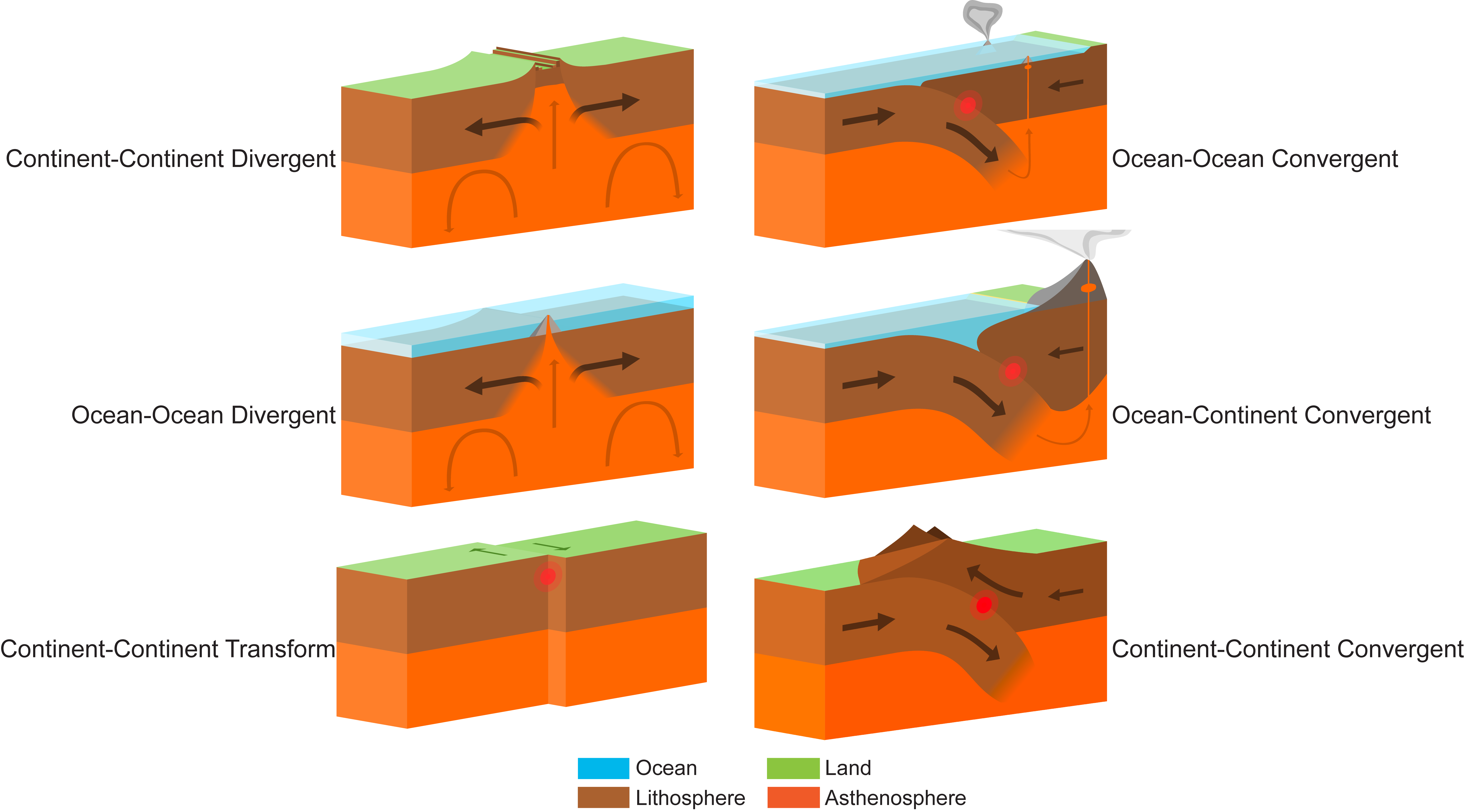
Lithospheric plates move around the globe in different directions and come in many different shapes and sizes. Their movement rate is millimeters to a few centimeters per year, similar to the rate that your fingernails grow. Motion between tectonic plates can be divergent, convergent, or transform. In divergent boundaries, plates are moving away from each other; in convergent boundaries, plates are moving toward each other; and in transform boundaries, plates are sliding past each other. The type of crust on each plate determines the geologic behavior of the boundary (Figure 1.1).
Exercise 1.1 – Reconstructing Positions of Continents Using Wegener’s Evidence
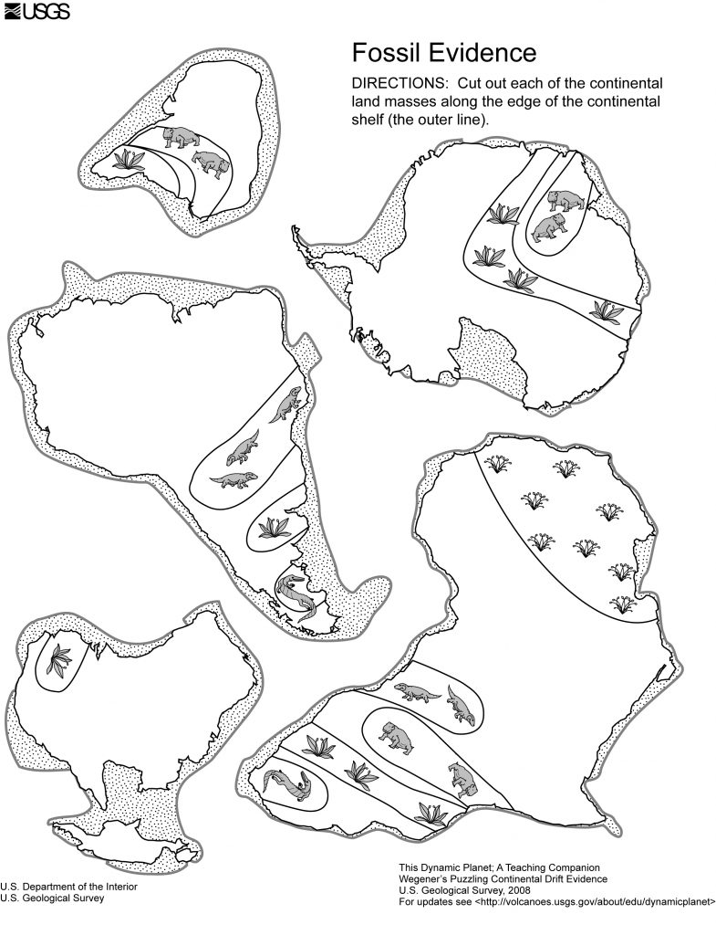
When Alfred Wegener came up with his continental drift hypothesis in the early 1900s, he used several lines of evidence to support his idea. He also proposed that 200 million years ago, all continents were together in a single supercontinent called Pangea. In this exercise, you will use the fit of the continents and matching fossil evidence to piece together Pangea. This exercise is adapted from “This Dynamic Planet” by the USGS.
- Individually or as a group, piece together the supercontinent Pangea.
- Label the landmasses of each continent in Figure 1.2.
- Color the fossil areas to match the legend below.
- Cut out each of the continents along the edge of the continental shelf (the outermost dark line).
- Try to logically piece the continents together so that they form a giant supercontinent.
- When you are satisfied with the fit of the continents, discuss the evidence with your classmates and decide if the evidence is compelling or not. Explain your decision and reasoning on the evidence.
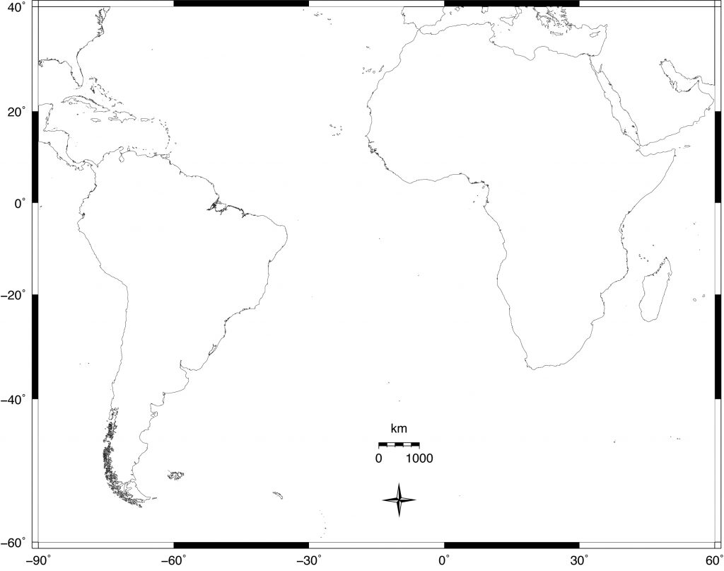
- Pangea began to break apart about 200 Ma resulting in the formation of the Atlantic Ocean. Using the map in Figure 1.3, calculate the spreading rate of the Mid-Atlantic Ridge in mm/yr. (Hint: measure the distance from the easternmost tip of South America to the inside curve of western Africa).
____________________
1.2 Plate Tectonics, Earthquakes, and Volcanoes
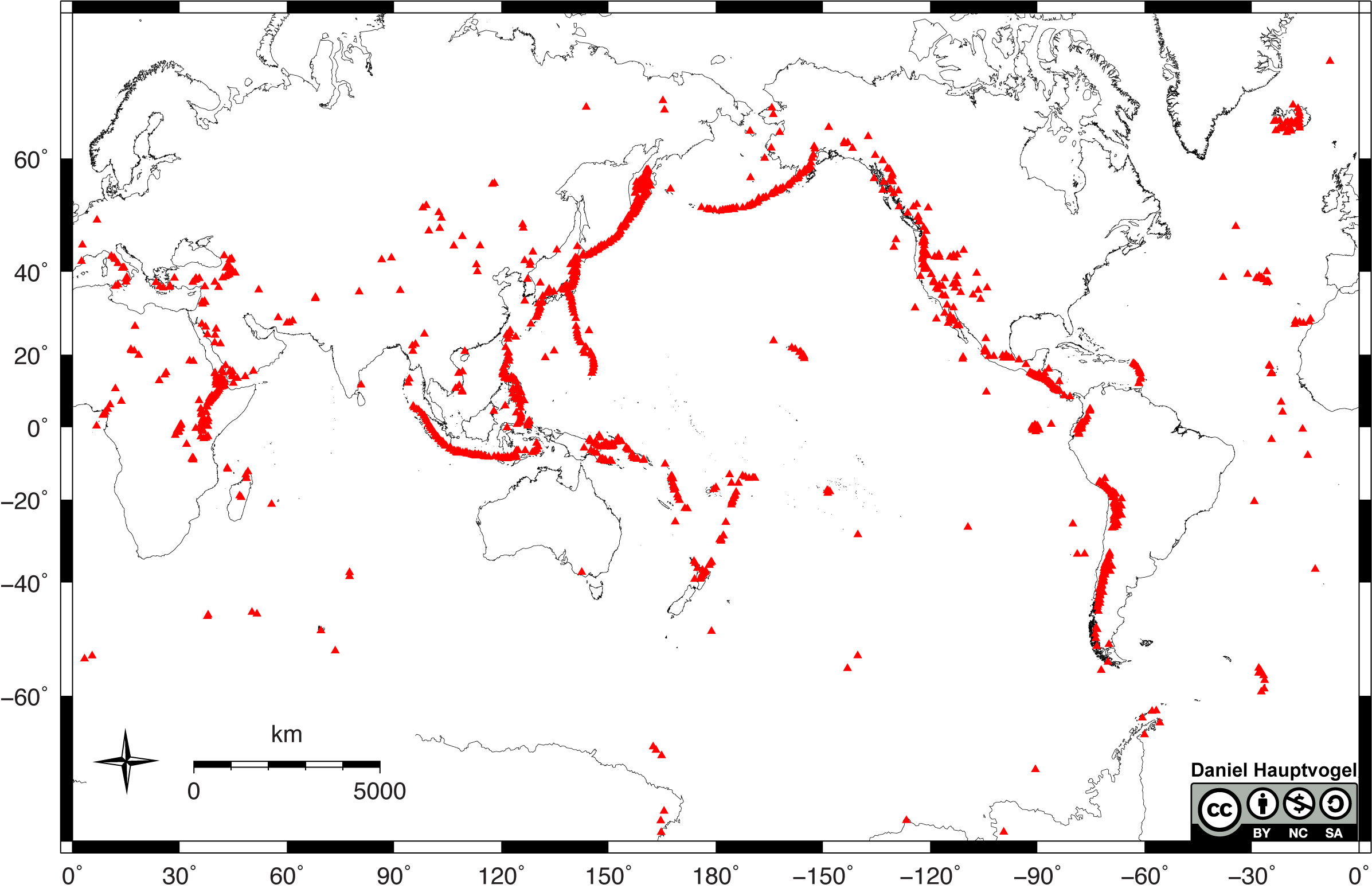
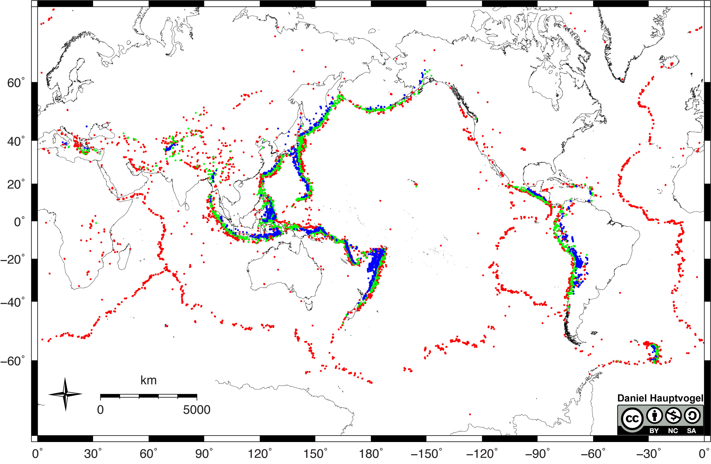
Plate tectonic boundaries are often associated with earthquakes and volcanic activity. By looking at maps for the distribution of earthquakes and volcanoes worldwide (Figures 1.4-1.5), you can interpret the boundaries between the major tectonic plates. Generally, divergent plate boundaries are characterized by shallow earthquakes and some volcanism. Convergent boundaries have a range of earthquake depths from shallow to deep, and many have volcanoes as a result of subduction. Subduction occurs in convergent boundaries where the denser, oceanic plate descends into the mantle beneath the overriding plate. Convergent boundaries also tend to produce linear and curved mountain belts. Transform boundaries typically have shallow earthquakes and no volcanoes.
Exercise 1.2 – Modern Examples of Plate Tectonic Boundaries
Each type of plate boundary has distinct earthquake and volcanic patterns. Using observational and critical thinking skills, answer the following questions:
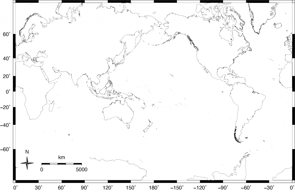
- Observe the patterns amongst the earthquake and volcano location maps (Figures 1.4-1.5). Hypothesize where you think the major plate boundaries exist and draw those boundaries on the blank map in Figure 1.6 using three different colors to identify the type of motion for each boundary (example: red for divergent boundaries, blue for convergent boundaries, and green for transform boundaries).
- Which type of boundary (divergent, convergent, or transform) is the most abundant? ______________________________________
- On the same map where you drew in plate boundaries (Figure 1.6), identify locations where each type of these boundaries are located:
- Continent-Continent Convergence (CCC)
- Ocean-Ocean Convergence (OOC)
- Continent-Ocean Convergence (COC)
- Continent-Continent Divergence (CCD)
- Ocean-Ocean Divergence (OOD)
- Continent-Continent Transform (CCT)
- What type of plate boundary is associated with most of the deep earthquakes?______________________
- Describe the pattern in earthquake depth from the coast to inland at subduction zones.
- Critical Thinking: The San Andreas Fault in California is a transform fault. Is there any evidence in the earthquake and volcanic activity that suggests this fault did not always have transform motion? Explain.
Earthquake locations can tell you more about an area than what type of plate boundary is there. For example, in subduction zones, most earthquakes occur along the boundary between the subducting slab and the overriding slab. The angle of subduction is not always constant and can vary from one boundary to the next and can even vary along the same boundary. When a plate subducts at a low angle, it is called flat-slab subduction. The effects of flat-slab subduction are many, including shallower earthquakes, uplifting of mountains, and the location and activity of volcanoes.
Exercise 1.3 – Interpreting Subduction Angle from Earthquake Data
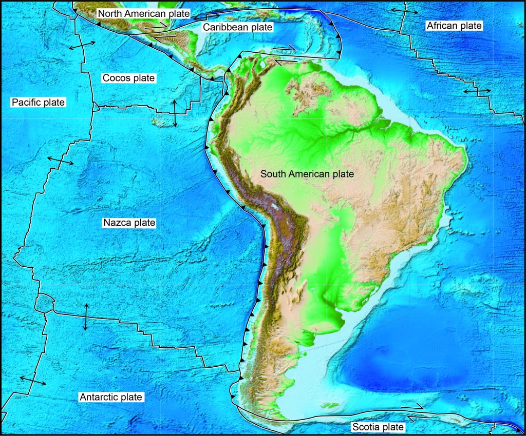
The Western margin of South America is a tectonically active region where the Nazca Plate subducts under the South American Plate (Figure 1.7), creating the Andes Mountains. Even though the entire coast is part of the same subduction zone, the subduction process doesn’t look the same throughout. Tables 1.3 and 1.4 contain earthquake data from two different locations of the subduction zone, one from central Chile and another near the Chile-Peru border. The location data are the distance each earthquake was from the trench and how deep within the Earth it was.
- Using the graph paper provided by your instructor, plot the distance of the earthquake foci (hypocenters) from the trench on the horizontal axis and the depth of the earthquakes on the vertical axis; the recommended scale is 1 cm = 10 km. Connect the plotted points to create an approximate cross-section of the subduction zone at the two locations.
- Look at the graph you made, which region has a steeper subduction angle, the Chile-Peru border or central Chile? ____________________
- Partial melting of the asthenosphere above the subducting slab occurs at a certain depth and leads to volcanism. In which location do you think volcanoes are closer to the coastline? Why?
| Distance from trench (km) | Depth (km) |
|---|---|
| 160 | 10 |
| 200 | 30 |
| 220 | 50 |
| 300 | 65 |
| 370 | 125 |
| 500 | 190 |
| 300 | 100 |
| 250 | 65 |
| 210 | 40 |
| 280 | 80 |
| 450 | 175 |
| 400 | 140 |
| 410 | 150 |
| Distance from trench (km) | Depth (km) |
|---|---|
| 100 | 10 |
| 170 | 40 |
| 220 | 65 |
| 400 | 90 |
| 200 | 50 |
| 120 | 20 |
| 500 | 110 |
| 350 | 85 |
| 300 | 75 |
| 250 | 60 |
| 280 | 75 |
| 200 | 55 |
| 260 | 90 |
1.3 Plate Tectonics and Topography
Geologists can observe most of the processes occurring at plate tectonic boundaries today (earthquakes, volcanoes, mountain building, etc.). However, understanding the plate tectonic activity of the geologic past is more difficult because the events have already happened. Hence, geologists use processes that occur in the present to interpret processes that occurred in the past. This is known as uniformitarianism. One way geologists can interpret ancient plate tectonic activity is to look at the topography of an area. Topography is the study of shapes and features of the land surface. When studying features on the seafloor, the topography is instead referred to as bathymetry because this data is referencing how deep a feature is. There are numerous ways of looking at the topography of Earth’s surface, including satellite imagery, topographic maps, shaded relief maps, and digital elevation models.
Exercise 1.4 – Interpreting Plate Boundaries from Topographic Profiles
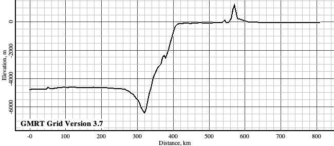
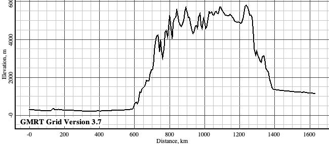
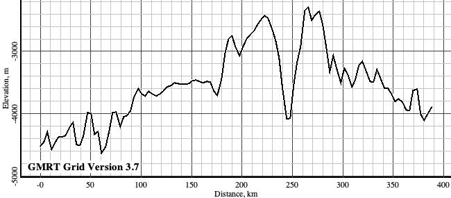
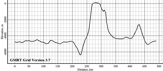
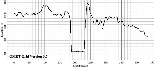
Below are five topographic profiles showing different plate boundary configurations. A topographic profile is a graph that shows elevation changes as you walk from one point on the Earth to another. These are all made with vertical exaggeration (length/elevation) of 50:1. This overemphasizes the changes in topography. In all of these profiles, the 0 value on the vertical axis is at sea level.
- For the topographic profiles in Table 1.4, identify what types of plate boundaries are shown using the names from Figure 1.1. Pay close attention to the y-axis versus x-axis.
- On each profile, draw the location of the boundary between the two plates. You can show this as a single line.
- For each profile, label features such as oceanic and/or continental crust, mid-ocean ridges, volcanoes, mountain belts, and trenches.
- Indicate which direction each tectonic plate is moving (you can use arrows for this).
| Profile | Type of Boundary |
|---|---|
 |
|
 |
|
 |
|
 |
|
 |
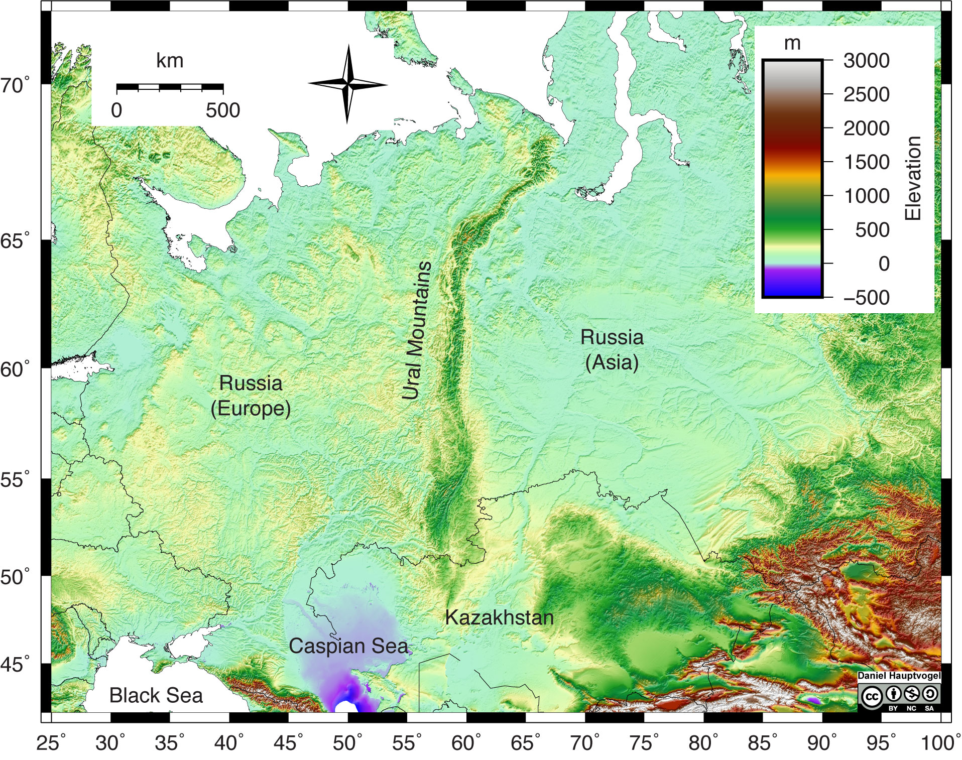
Geologists can use topography to get a broad sense of the tectonic history of an area. Generally speaking, plate tectonic activity tends to produce elevation changes at or near the plate boundary, especially in convergent settings. The collision of two plates leads to suturing; the two plates become one when the collision ends. Evidence of these ancient boundaries is most commonly in the form of linear mountain belts that are not currently near a plate tectonic boundary. For example, an eroded, linear mountain belt in the middle of a continent would indicate that area was part of a convergent boundary deep in the geologic past and likely a continent-continent collision. The Ural Mountains in Russia fit this description (Figure 1.8). They formed during an orogeny 240 to 300 million years ago and now serve as the boundary between Europe and Asia.
Exercise 1.5 – Interpreting Ancient Plate Tectonic Boundaries
- Over time mountain ranges are weathered and eroded, and the topography slowly goes back to base level. Which do you think is more likely to be older, a mountain belt with higher elevations or a mountain belt with lower elevations? Explain your reasoning.
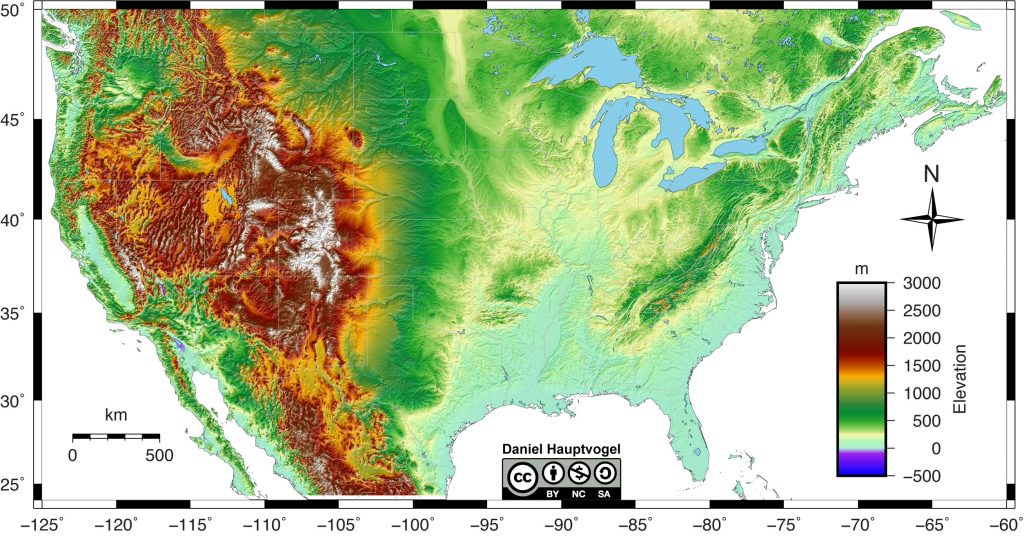
- Look at the topographic map for part of North America (Figure 1.9). Mark two areas that you think have been through major convergence of tectonic plates.
- Which of the two areas do you think is older? What evidence from the map supports your hypothesis?
- Look closely at the western portion of the North American continent. You should be able to notice differences in the patterns that make up the mountains. Each pattern represents a different geologic region. Draw boundaries on the map that separate these different geologic regions and then describe the patterns you observed to distinguish them (Hint: There are at least three).
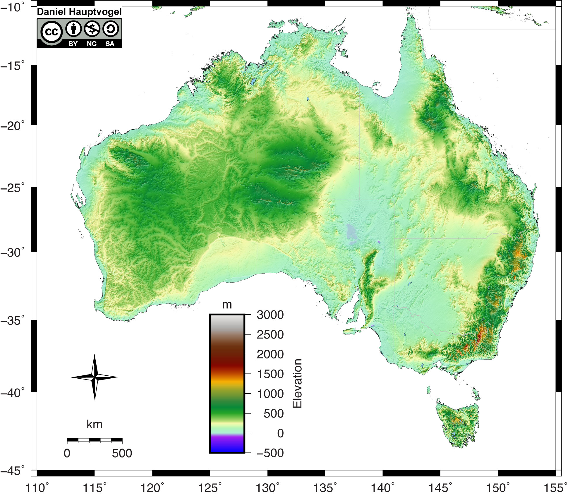
- Tectonic plate activity is often associated with mountain building. Based on Australia’s topography (Figure 1.10), explain whether or not you think the region is tectonically active today?
- On the topographic map of Australia (Figure 1.10), mark an area that you think was a plate boundary in the geologic past but is no longer active today. Explain your reasoning for marking this area.
- Critical Thinking: Both of these maps contain areas on continents that are below sea level. Come up with a hypothesis that explains how this can happen.
When most people think about tectonic plate boundaries, they often visualize parallel, symmetric lines separating the plates. This is not always the case in the real world as many plate boundaries are curved or segmented; this is because Earth is a sphere. Think about this: if you had a ball and tried to wrap it with a flat sheet of paper, would the paper wrap around it perfectly smooth? The answer is no; the paper will want to fold in some places and tear in other places. The tectonic plates behave similarly to the paper. Of course, other factors affect the shape of a boundary. Evidence of these plate boundaries is also contained in the topography of continents because not all mountain belts are straight lines.
Exercise 1.6 – Ancient Plate Boundaries in Texas, Oklahoma, New Mexico, and Northeastern Mexico
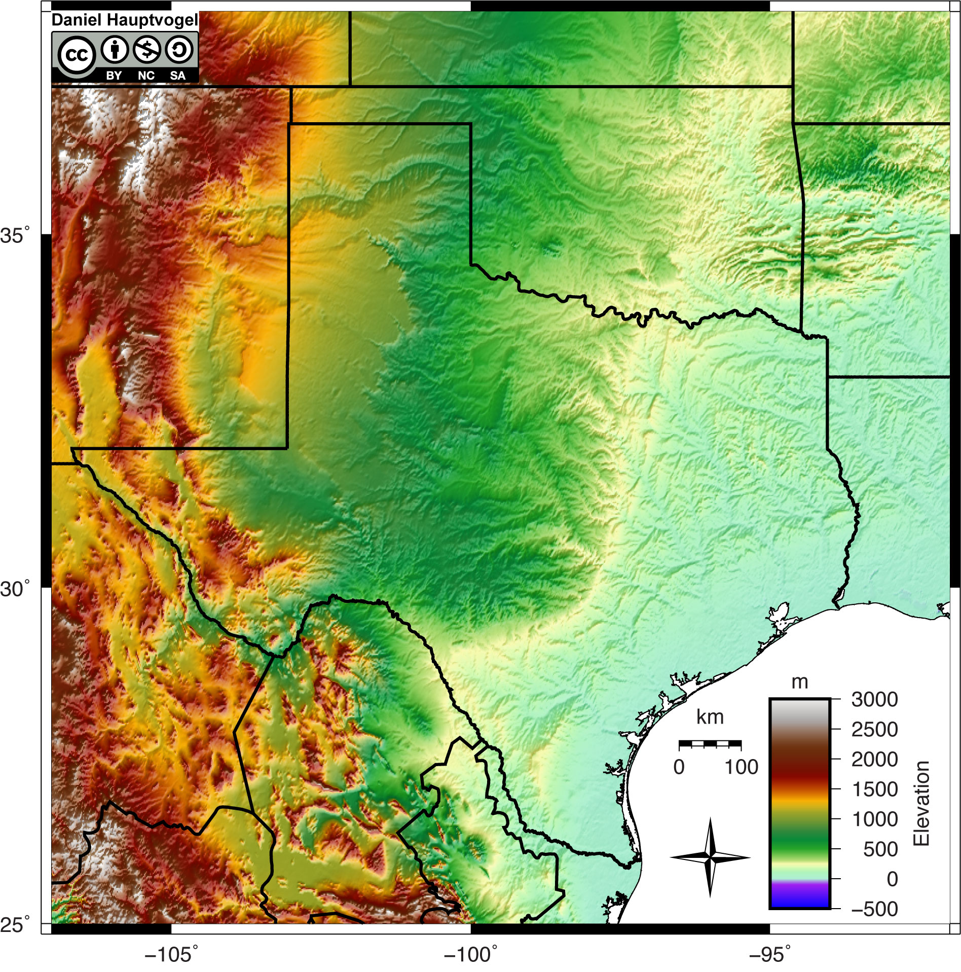
Below is a topographic map of Texas, Oklahoma, New Mexico, and northeastern Mexico (Figure 1.11). This area is not near an active plate tectonic boundary today; the closest boundary is in the Gulf of Mexico. However, there is evidence in this topography to indicate it was part of a plate tectonic boundary at least twice in the geologic past.
- Based on the topography, mark two areas that have been part of a plate tectonic boundary in the geologic past. Topographic changes do not need to be symmetric as some tectonic processes are not symmetric.
- One of these boundaries is older than the other. Label the old and young boundaries.
- One of these boundaries has highs and lows within the belt. What tectonic process creates low topography?
- One of these boundaries splits into two branches. What is the angle between these branches?
As tectonic plates move, they ride over stationary “hotspots” of heat from the mantle. Hotspots are still a poorly understood geologic phenomenon, but they allow extremely hot mantle material to rise close to the surface. Hotspots are marked by volcanoes, which come from melting of the mantle and crust directly above a hotspot. If they occur under oceanic crust, they produce basalts. On the other hand, if they are under continental crust, they form both basalts and rhyolites, often called bimodal volcanism. Under North America, there are two hotspots: The Yellowstone hotspot, which is currently under Yellowstone National Park in Wyoming and Montana, and the Anahim hotspot in central British Columbia, Canada. As the North American Plate moves over these hotspots, calderas form from volcanic activity; one of the largest volcanic eruptions ever occurred when the Gray’s Landing volcanics erupted 8.72 million years ago above the Yellowstone hotspot. One of the controversies is whether the hot spot is still capable of supereruptions or whether the volume of eruptive material is waning.
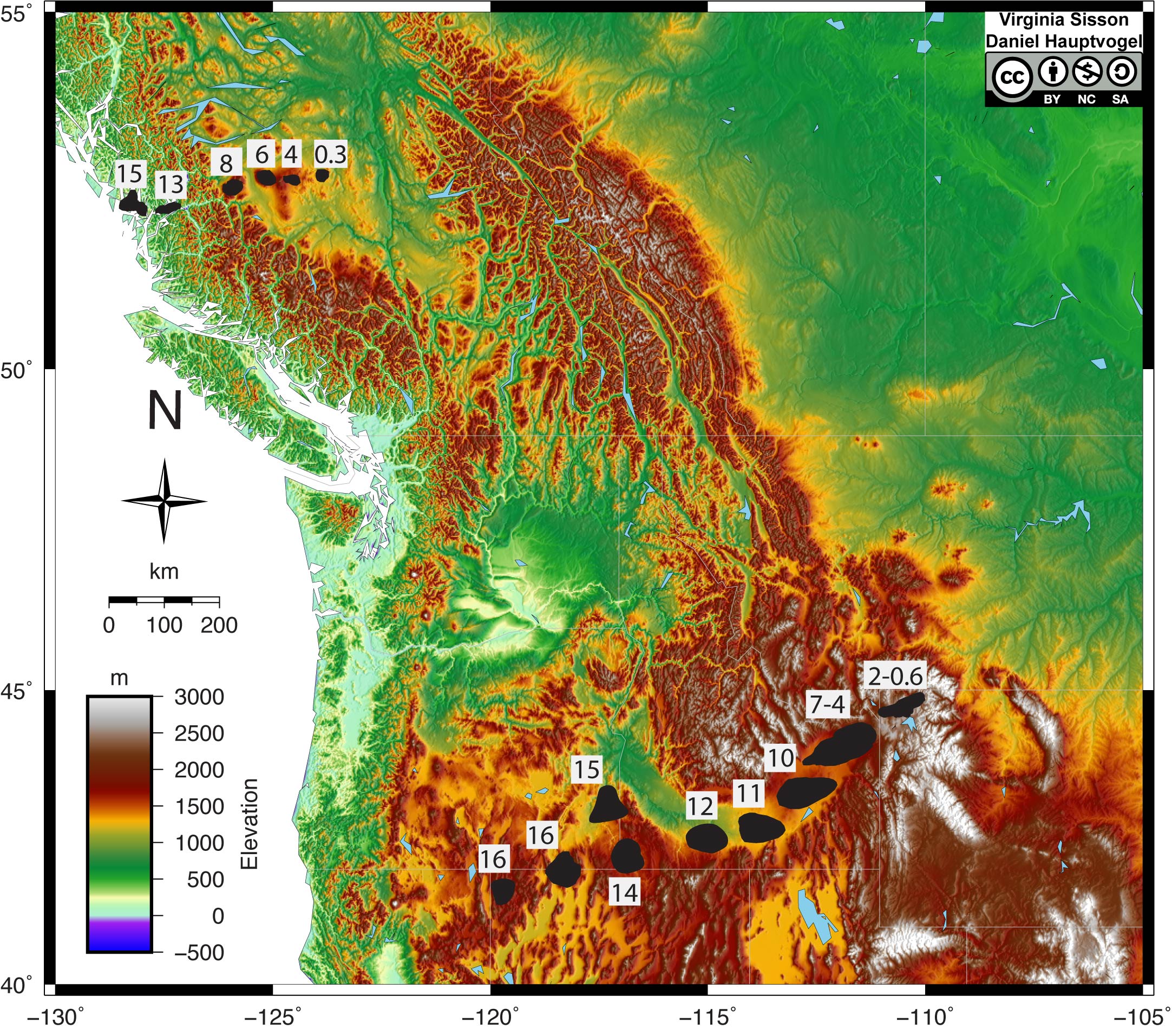
Exercise 1.7 – Tracking North American Hotspots
Use Figure 1.12 to answer the following questions about North American hotspots.
- Use a protractor to measure the direction of the plate motion for each hotspot track. This is called the azimuth and is usually measured clockwise from the north.
- Angle for Yellowstone: ____________________
- Angle for Anahim: ____________________
- How fast is the North American plate moving over these hotspots? Measure the length of the hotspot eruptions from the youngest to oldest. If you divide the length by the maximum age, this will give you the rate of plate motion. Convert this to mm/year (km/my) as most plate motions are low-velocity rates.
- Rate of plate motion for Yellowstone: ____________________
- Rate of plate motion for Anahim: ____________________
- Are these the same for the two hotspots? ____________________
- If not, why are the azimuth and the rates different if North America is a rigid plate tectonic block?
The answer may not be apparent as we don’t often move things around on a sphere. Instead, we think of motion as a straight line from point a to point b. These hotspots are on the North American plate which means the plate rotates around a point in the middle of northern Quebec. Since they rotate around a point on a sphere, different locations on the plate move at dissimilar speeds and directions. Geoscientists call this an Euler pole.
- Geoscientists have measured instantaneous global plate motions through various techniques such as global positioning satellites (GPS) and very-long baseline interferometry (VLBI). This data is used to calculate the rates of motion between two plates. There are several online plate motion calculators available; we will use the one created by UNAVCO. Use the latitude and longitude for the young end of each hotspot and calculate the rate and direction of plate motion. Fill this out in Table 1.6. This website will give you other information that is not relevant to this lab exercise.
Table 1.6 – Answer area for Exercise 1.7c Hotspot Speed (mm/yr) Azimuth Direction Yellowstone Anahim - Critical Thinking: Are the UNAVCO results similar to your calculated results from b? If not, why might you get different answers?
- Has the rate of motion of the North American plate been constant along the hotspot track?
- Which hotspot track has more volcanism? Yellowstone or Anahim? Be sure to compare the volcanism over the same time period. Consider the size of the calderas when you answer this question.
- Critical Thinking: Can you explain why one of these has larger volcanic eruptions? You may be able to use the topography to help you understand each area’s tectonic history to help you answer this question.
Additional Information
Exercise Contributions
Daniel Hauptvogel, Virginia Sisson, Carlos Andrade, Melissa Hansen
References
Knott, T.R., Branney, M.J., Reichow, M.K., Finn, D.R., Tapster, S., and Coe, R.S., 2020, Discovery of two new super-eruptions from the Yellowstone hotspot track (USA) Is the Yellowstone hotspot waning? Geology, v. 48, p. 934-938. doi.org/10.1130/G47384.1
Martinod, J., Husson, L., Roperch, P., Guillaume, B., and Espurt, N., 2010, Horizontal subduction zones, convergence velocity and the building of the Andes. Earth and Planetary Science Letters, v. 299, pp. 299-309. DOI:10.1016/j.epsl.2010.09.010.
Google Earth Locations
the uppermost layer of the Earth as defined by physical properties. It is composed of the crust and uppermost, rigid part of the mantle.
a linear feature where two plate boundaries move apart from each other
a plate boundary where two plates move towards each other
a plate boundary where two plate boundaries move horizontally beside each other
the hypothesis proposed by Alfred Wegener in 1915 that stated the continents were moving
the climate during some past geological time
an ancient landmass of almost all of the continental crust or supercontinent that formed in the late Paleozoic
a process that occurs at convergent plate boundaries where one plate descends beneath another into Earth's mantle.
an aligned group of mountain ranges that form from the same cause, usually an orogeny or convergent plate boundary
a topographic depression of the sea floor, relatively narrow in width, but very long usually associated with convergent plate boundaries
the theory that the same natural laws and processes that operate in our present-day scientific observations have always operated in the universe in the past and apply everywhere in the universe. It is sometimes referenced as "The present is the key to the past".
the zone where two continental plates meet during convergence
a mountain-building event typically resulting from a convergent tectonic boundary
linear volcanic regions that are probably fed by underlying mantle that is anomalously hot compared with the surrounding mantle
a layer in the Earth or a planet that is between the core and crust


