
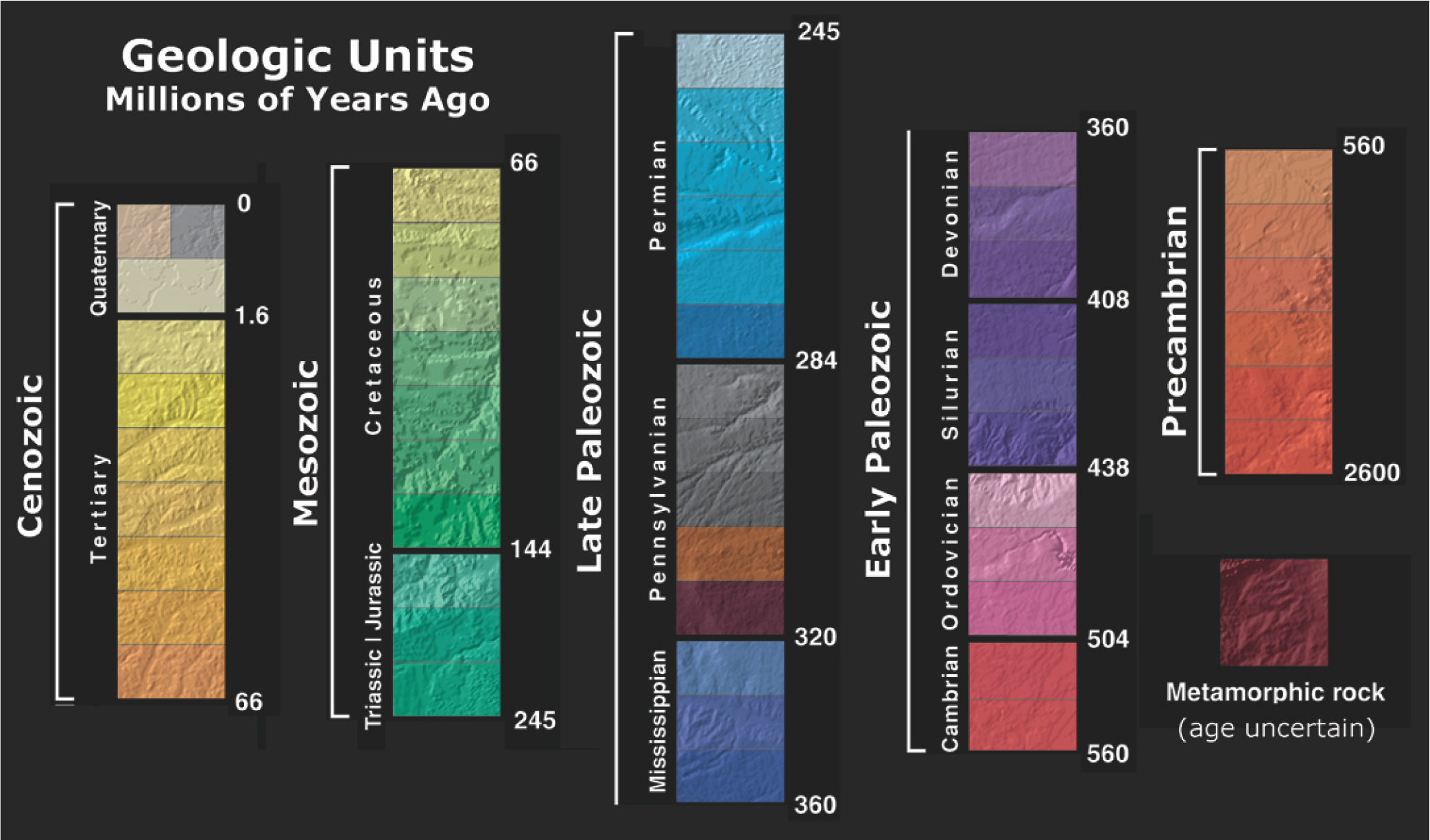
Chapter 10: Interpreting Earth’s History using Maps
The 2nd edition is now available! Click here.
Learning Objectives
The goals of this chapter are to:
- Understand how fossil locations can be found using geologic maps
- Interpret geologic provinces using maps
- Construct geologic histories using maps
Some of the maps in this chapter can be printed on poster paper from large PDF files found here (opens in a new tab).
10.1 Introduction
Throughout this lab manual, you’ve been looking at geologic maps for many purposes, such as locating different types of rocks, finding plate boundaries, investigating stratigraphic relationships, and more. However, there are few things you have yet to do. One important skill is using geologic maps to find fossils. This involves using your knowledge of the environment fossil used to live such as deep marine, swamp, or deserts, and the age of the stratigraphic unit. You will need to use your knowledge gained from Chapters 5 to 8.
The other is relating many different features such as magmatic activity, paleoenvironment, deformational history, metamorphism to create geologic provinces that share a common Earth history. Typically a geologic province is many 100’s of kilometers in size. They can be a single geologic feature (for example, a sedimentary basin or thrust belt) or a combination of contiguous geologic features. To define geologic provinces, you will use almost all of the concepts you’ve learned over this course. Why is this important? Well, you can use a geologic province to find resources such as oil and ores. They also will share a similar story of Earth.
You may also identify provinces on other planets, such as Mars, which has three geologic provinces; 1) Tharsis, which is volcanic, 2) northern highlands which have a smooth topography, and 3) southern highlands, which are rugged and heavily cratered (see Golombek and Phillips, 2010). If you were going to go put a settlement on Mars, which of these would you pick to settle just knowing this information?
10.2 How to Locate Fossils
When scouring an area for fossils, the easiest to find are those exposed by weathering from wind or water. In 2020, a California state park ranger was checking out a watershed near the Mokelumne River. He spied a fossilized tree. Then he came back and found that erosion over the year exposed a whole petrified forest and fossilized bones from Miocene mammalian megafauna such as ancestors of horses and rhinos, gomphotheres (similar to elephants but with twice as many tusks), giraffe-sized camels, and many other creatures. Now a team of paleontologists and geologists is excavating the site. You may ask why so many fossils are in one place and why they eroded away so quickly. Well, they were either buried in a mudslide or volcanic ash such as a lahar. Both of these are easy to erode rapidly and expose all the bones of the trapped creatures. So, keep on looking, and perhaps you’ll find some of your own fossils.
Once you have found a fossil, what comes next? There are many resources available for amateur fossil collectors. After your initial discovery, if you think you might have an interesting find, you can contact other paleontologists for help or use web resources. If this is a new discovery or unusual specimen, paleontologists will excavate the fossils by removing any overburden and bring them to a museum or other collection. Small fossils such as mammalian teeth are sometimes collected by dry sieving sands.
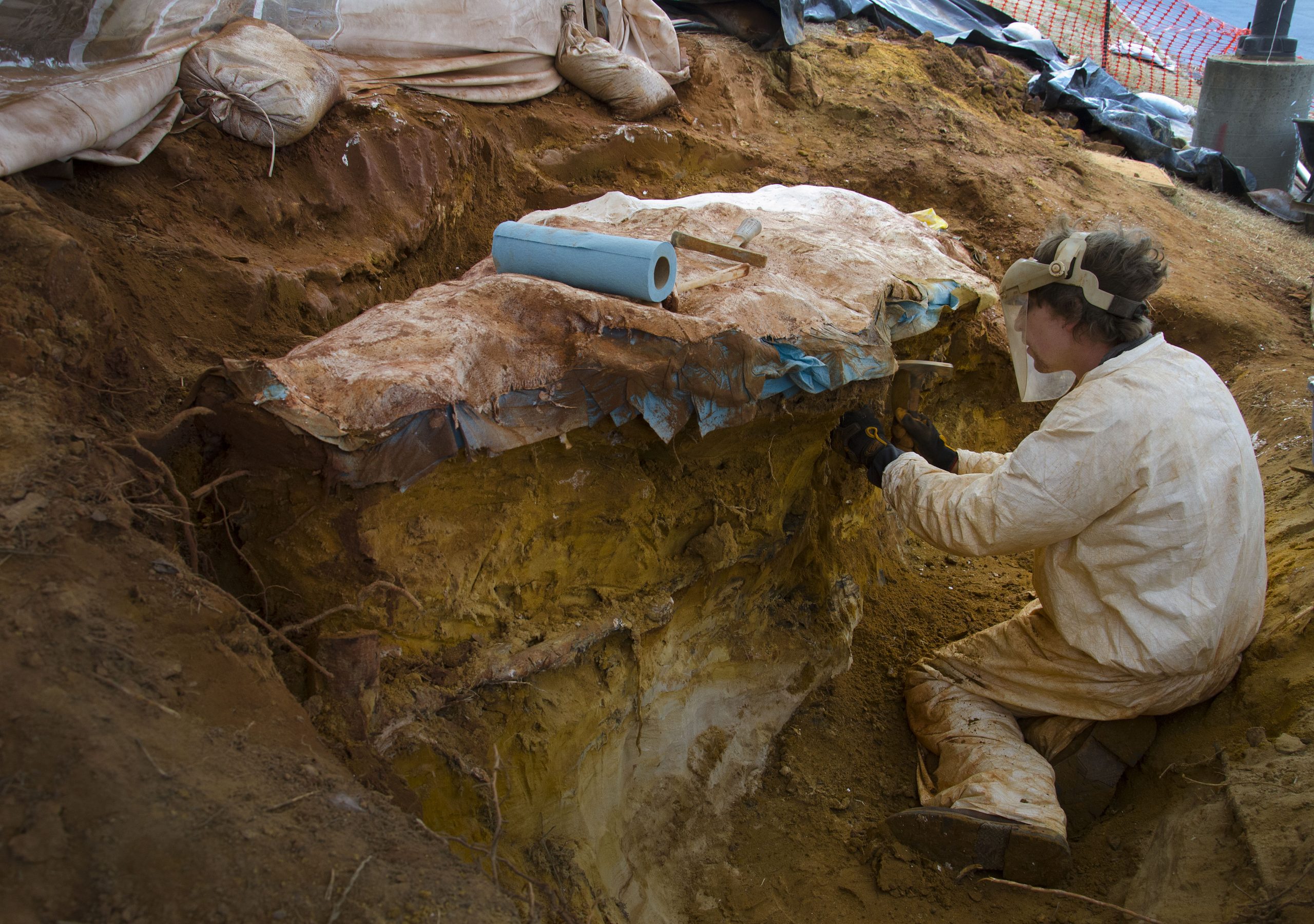
Many think this is glamorous work similar to what is seen in movies such as Indiana Jones or Jurassic Park. In reality, it often involves tedious work sitting in a dry, hot, dusty quarry removing overburden for many days, especially to expose large fossils. Or you may have to dig a trench around a large specimen to successfully get all of the fossil (Figure 10.1). These large fossils need to be encased in a plaster jacket before bringing them back to the lab. In contrast, delicate fossils are often wrapped in toilet paper to protect them. Plus, Indiana Jones’s job performance would not have been viewed favorably by his university.
Fossil collecting must be done with proper permission and possibly permits, especially if you are looking for fossils on public lands in the United States and Canada. It is important to know the local laws. For example, you can’t collect anything in a National Park. In a National Forest or Bureau of Land Management land, it is illegal to collect fossil bones but okay to take up to 25 pounds of fossilized wood per day, up to 250 pounds per year. So, before you start your own collection, be sure you have proper permission from either the landowner or the proper authorities to collect fossils.
Now that you are using fossils for more than just curiosity, you need to think about how to best preserve them and their future usefulness for others. Many amateur fossil collectors only record the fossil name and the formation. What kind of information do you think is needed?
- Location from GPS with latitude/longitude
- Do you need elevation?
- Additional descriptive details such as collected near a stream
- Do you need stratigraphic information?
- Age of formation?
- Orientation of the fossil relative to layering
- Labeling – should this be on a separate piece of paper or on the specimen, or both?
- What other fossils were found at this location?
Exercise 10.1 – Using Maps to Find Fossils
Now that you have all of the basics for fossil collecting, it’s time to go on a search. Fossils in museums are identified by location data and geologic age. Below is a map of all the fossil localities known in the United States from PaleoDB.
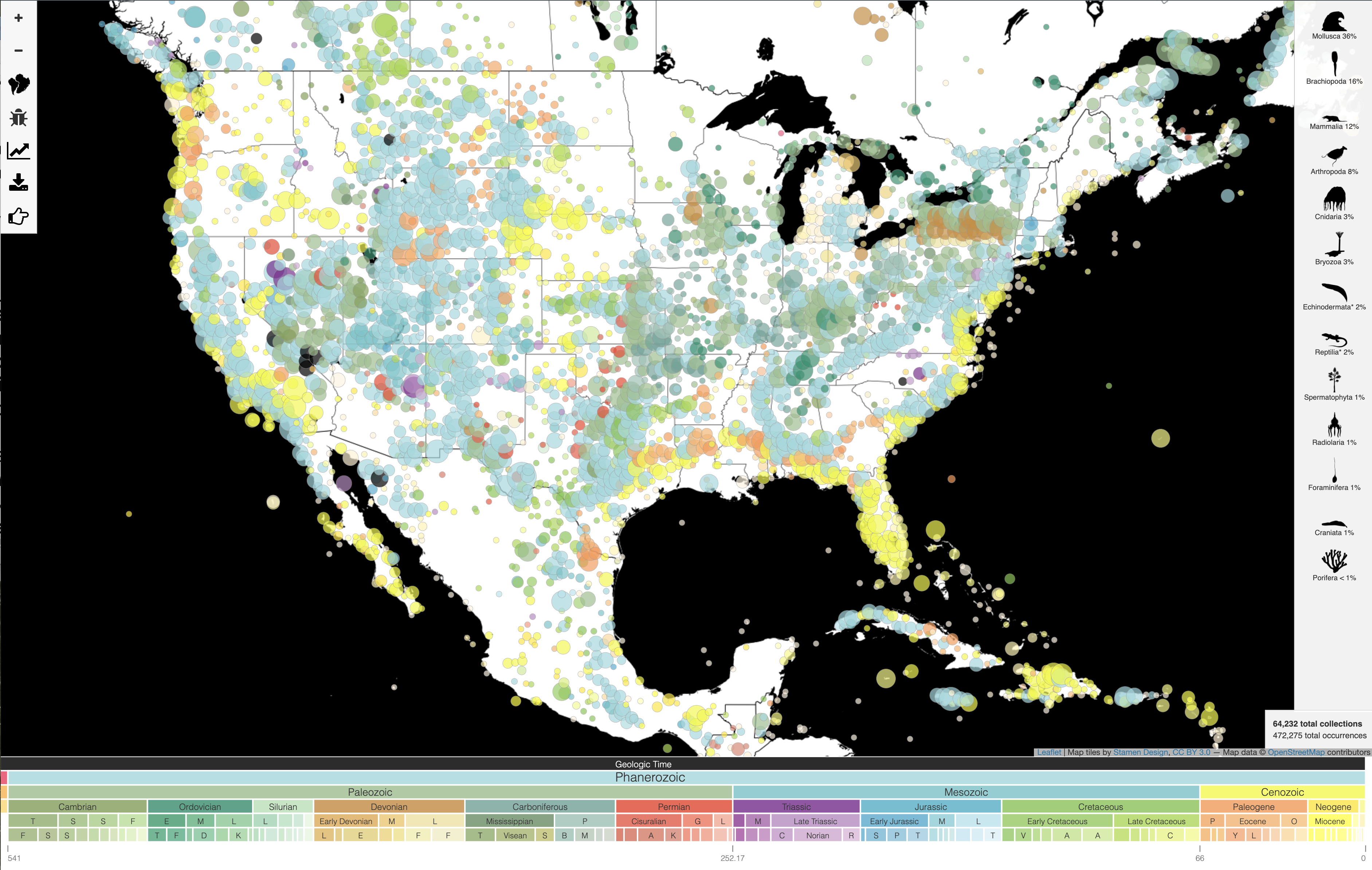
- On the map, mark a few locations that you think would be interesting to go visit. What is the age of the fossils you would find there? _______________________
- What type of fossils do you think you might find in these locations? Use your knowledge of fossil diversity through time shown in Chapter 7, such as Figure 7.7 or 7.18. ____________________
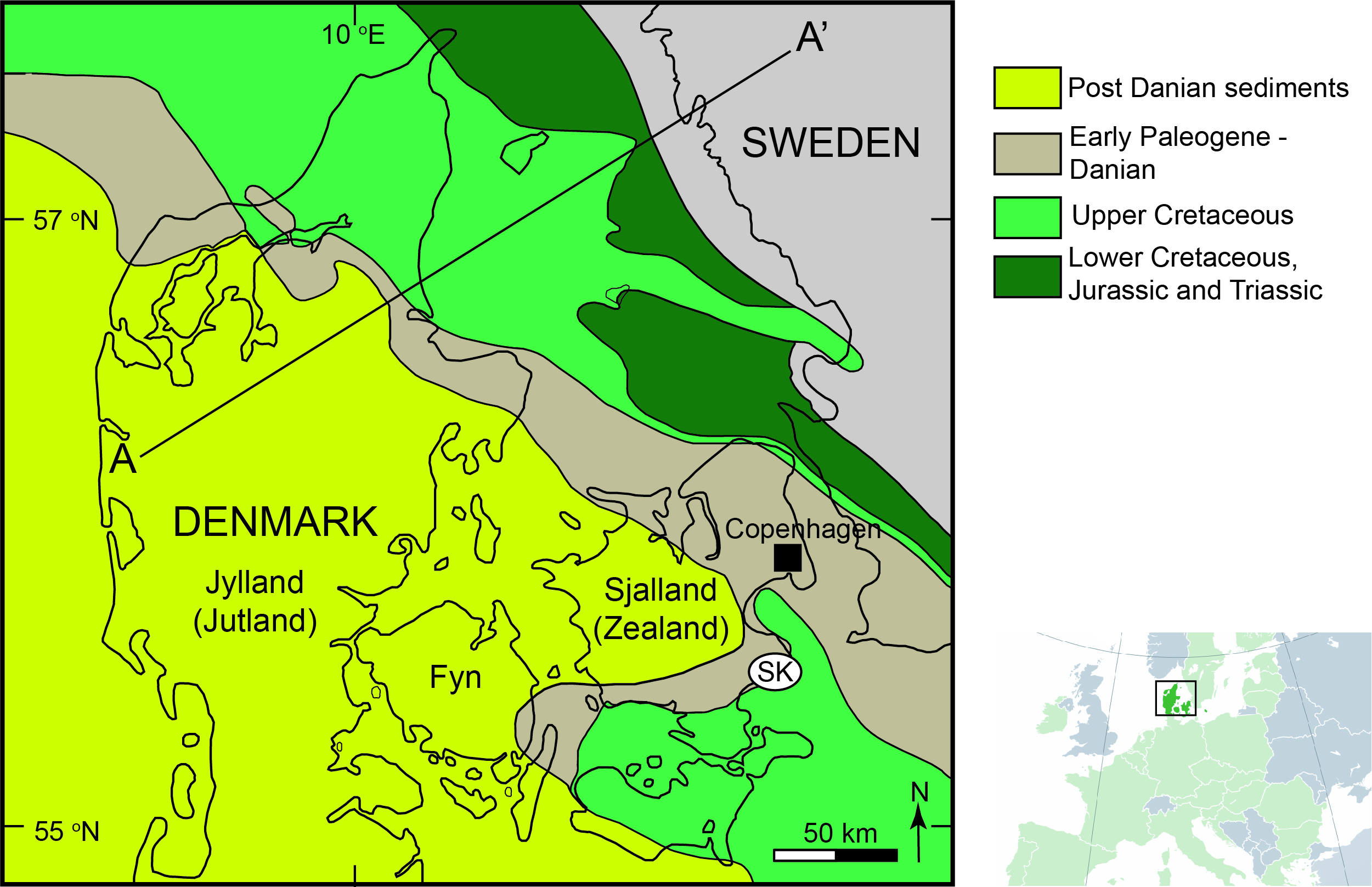
If you search online for the best places in the world to go look at fossils or collect them, the number one locality is the Burgess Shale (Exercise 9.4) to see the first soft-bodied animals (but you can’t collect here as it is a protected site). If you want to be in the United States, go to Calvert Cliffs in Maryland to collect shark teeth and more. However, if you want to combine a trip to Europe with this search, go to either the UNESCO World Heritage Site in the Jurassic Coast of the United Kingdom (Exercise 5.3) to collect ammonites or take a trip off the beaten track to Stevns Klint in Denmark. We’ll explore what fossils can be found here as well as their geologic history.
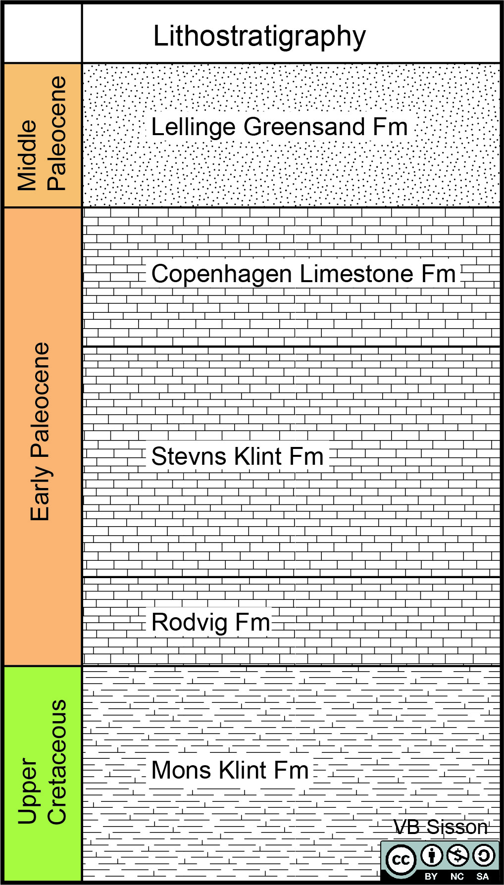
To start your exploration of Stevns Klint, first look at the geologic map (Figure 10.3) and then the stratigraphic column (Figure 10.4). To the east and north is Sweden, a part of the Precambrian Fennoscandian Shield made of Archean and Proterozoic gneisses and greenstones. The latest geologic event in southern Sweden was the Sveconorwegian orogen active between 1140 and 960 Ma; too old an area to have any fossils. North-south rifting associated with the break-up of Pangea in the Triassic created the Danish Basin, an extension of the Oslo Graben in Norway. After rifting, marine incursion can be seen as a section of carbonates. A marine setting can host many animals and might be a good place to collect fossils. During the Upper Cretaceous, deep marine carbonates composed of coccolithophores (algae) settled in the rift basin as a carbonate ooze and are now lithified as chalk. As the basin filled in, carbonates were deposited in bryozoan mounds in shallow water. Today, sea cliffs at Stevns Klint expose chalk at the base, then a clay layer rich in iridium, and finally a bryozoan limestone with chert nodules. This boundary between the Cretaceous and Danian (Paleogene) was initially described in 1847 by Desor.
Use the geologic map and stratigraphic section to address the geologic history of this region.
- What types of unconformity separates the Swedish Fennoscandian Shield from the Danish Basin? ___________________________________
- What major geologic event occurred in Stevns Klint? Hint: think through all of Earth’s history. _______________________
- This boundary is seen at the Stevns Klint location and elsewhere. Circle several other locations on the map that you may go to look for this boundary.
- What type of fossils would you find in the Mons Klint Formation? ______________________
- Do you think the same fossils occur in the Stevns Klint Formation? Explain. _____________________________
- Would you find Mosasaurs or Plesiosaurs in the Rodvig Formation? _______________
- In which formation would sample to collect echinoderms? _____________________
- Draw the boundary between the Cretaceous chalk and the Danian bryozoan mounds on this image. If you could get close to this cliff, this would be marked by a distinctive clay layer rich in iridium.
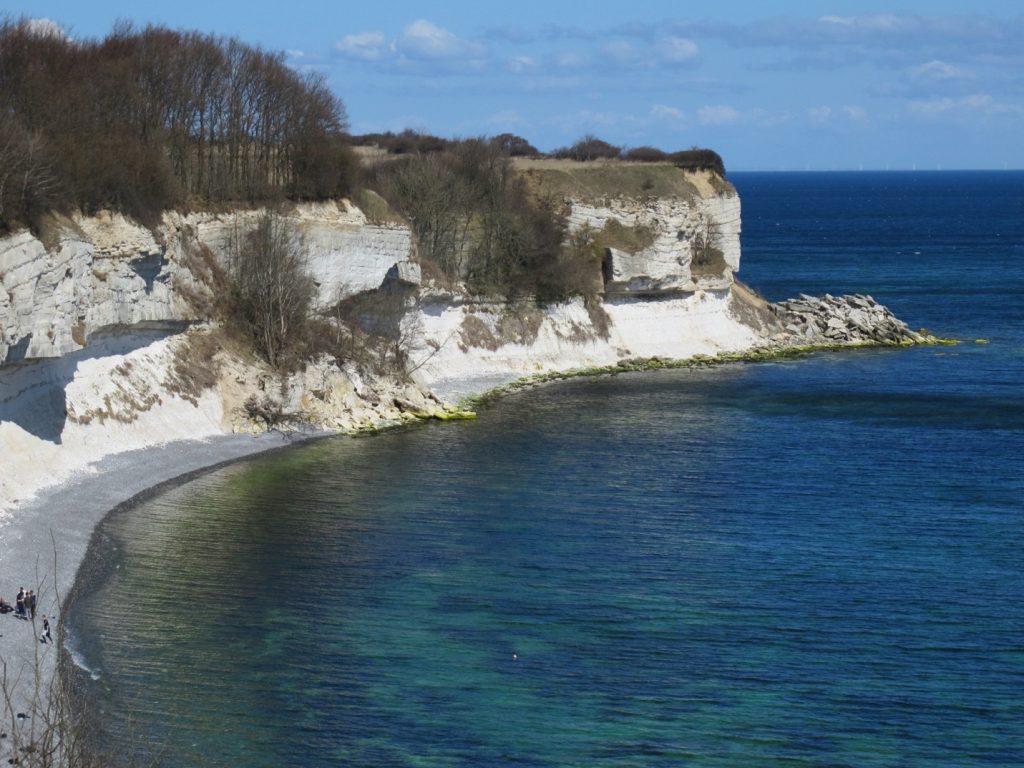
Figure 10.5 – Photo of Stevns Klint showing the Upper Cretaceous and chalk and Danian bryozoan mounds. Image credit: Lisa Risager CC. 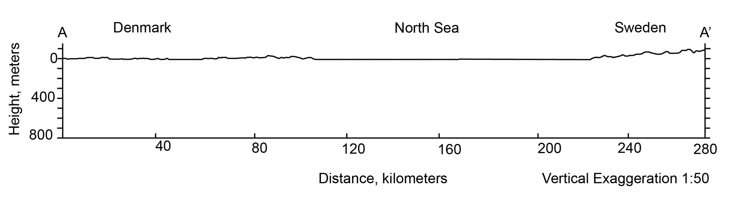
Figure 10.6 – Topographic profile across the Danish Basin. from A-A’ . Vertical exaggeration is 1:50. Image Credit: VB Sisson using Google Earth Pro for topography. CC-BY - What type of contacts are there between the sedimentary units? _______________________________
- The Danish Basin geologic map only has formations and does not have any strike and dip symbols (Figure 10.2). The topography in the area is very subtle; even with a very large vertical exaggeration of 1:50, you do not see much in the way of mountains on the cross-section. To make a cross-section, you will need to locate the boundaries between stratigraphic units along the cross-section. Then, using the outcrop picture, the rule of V’s, and the vertical exaggeration, you can determine the dip of the units. Draw a schematic cross-section along A-A’. This might be tricky as some of the units are not very thick.

10.3 Geologic Provinces
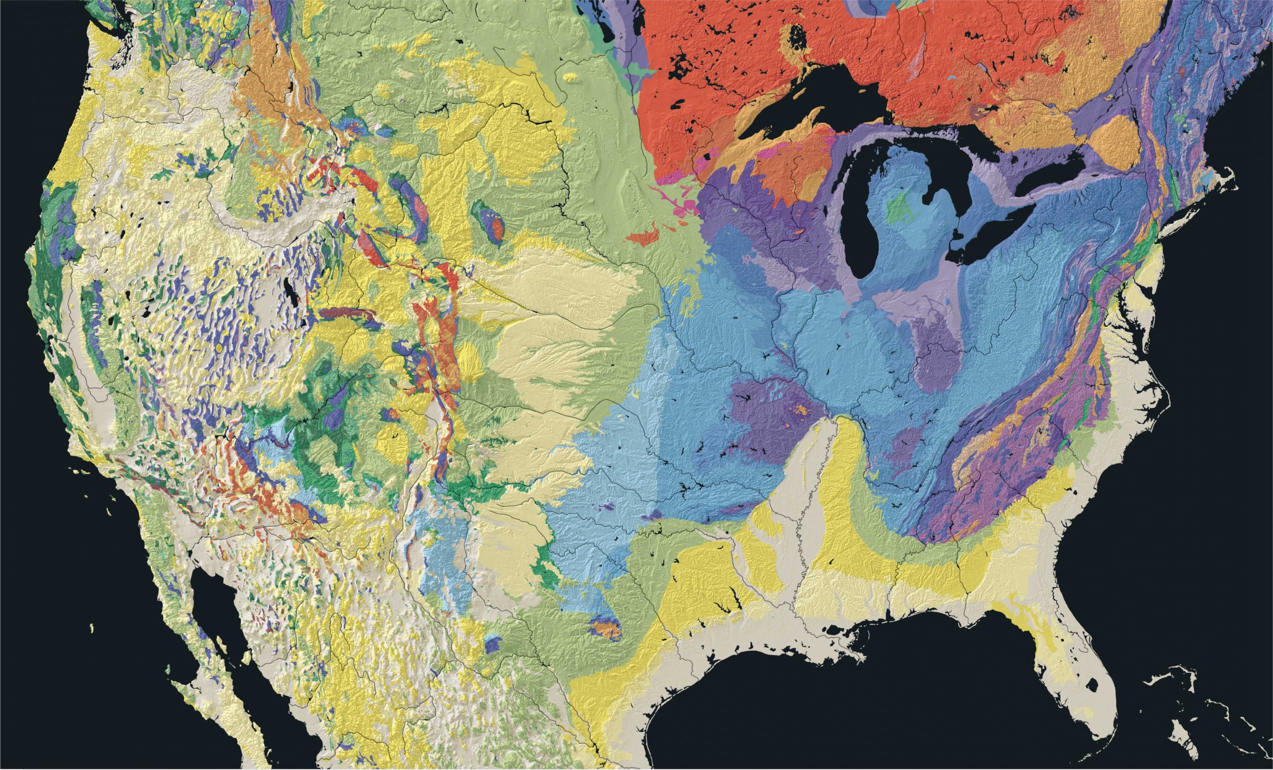
Have you ever looked at a geologic map of North America? You may not remember it, but part of the map you saw during the first week of lab was North America (Figure 0.9). The age and character of the rocks give rise to landscape characteristics (physiographic) and the types of soil and sediments that cover the surface. The modern landscape of the United States has been shaped by tectonic, climatic, sedimentary, and erosional processes.
On a grand scale, the contiguous United States is divided into eight physiographic regions which are then subdivided into 25 provinces. These are further subdivided into sections. We won’t worry about the smallest subdivisions. In comparison, Africa has eight regions with 17 provinces, and South America has only four regions with 27 provinces.
Exercise 10.2 – Geologic Provinces of the United States
People tend to be either “lumpers” or “splitters”. The “lumpers” like to group things together and join areas with similar characteristics. On the other hand, “splitters” like to subdivide characteristics into smaller and smaller groups. This is why you might find more or fewer physiographic provinces on maps from different geologists.
-
- Write a general statement about the topography of North America from the west coast to the east coast. Use Figure 10.7 as your reference.
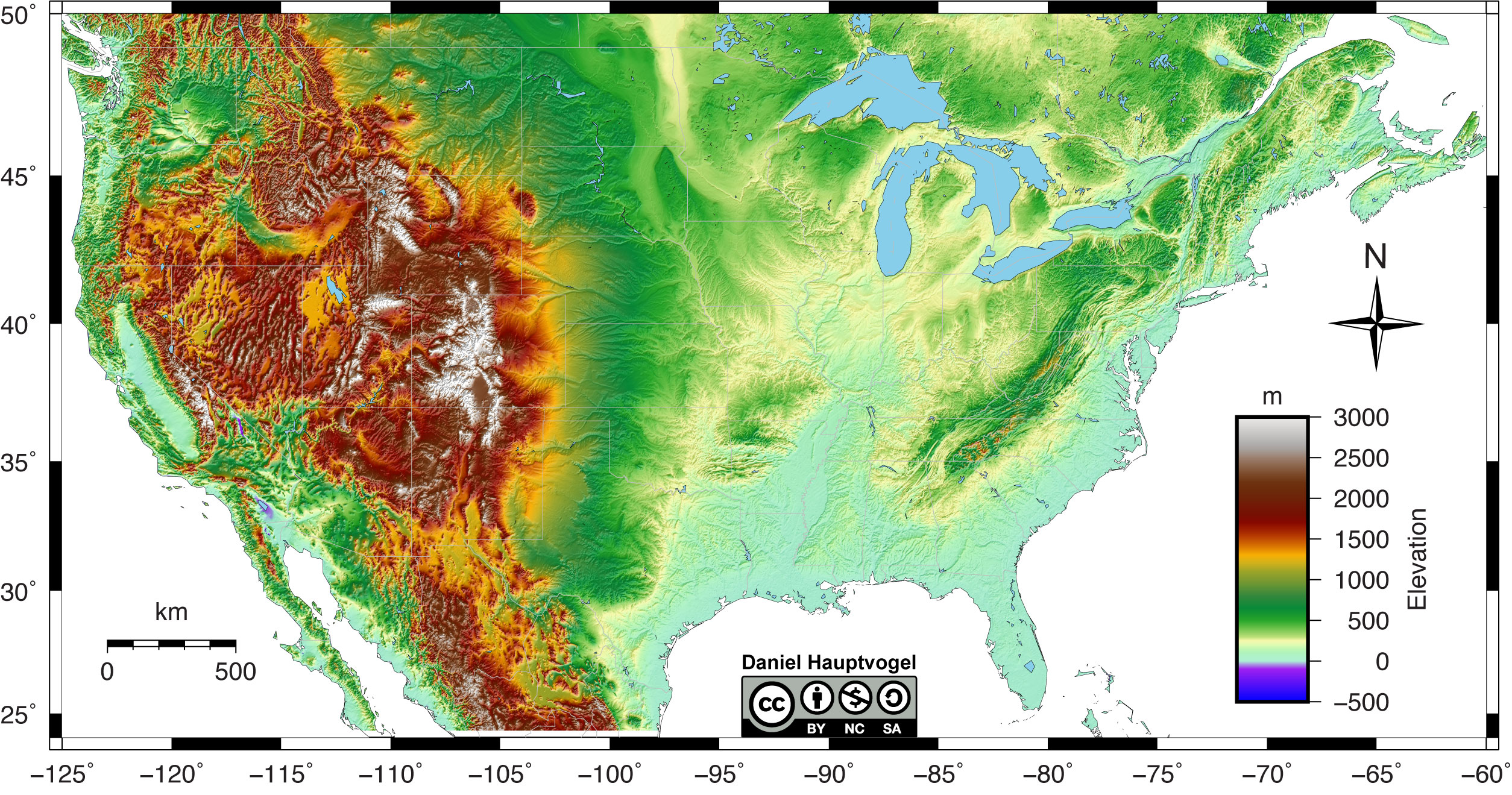
Figure 10.7 – Shaded relief map of the United States. Red and white colors represent high elevations, greens and yellow represent lower elevation, and purple and blue represent areas below sea level. Map scale reference is 40° latitude. Image credit: Daniel Hauptvogel, CC BY-NC-SA - On Figure 10.7, roughly draw how you would divide North America into different physiographic provinces based on topography. Use as many provinces as you think necessary. A marker might be best for drawing the boundaries.
- Write a general statement about the topography of North America from the west coast to the east coast. Use Figure 10.7 as your reference.
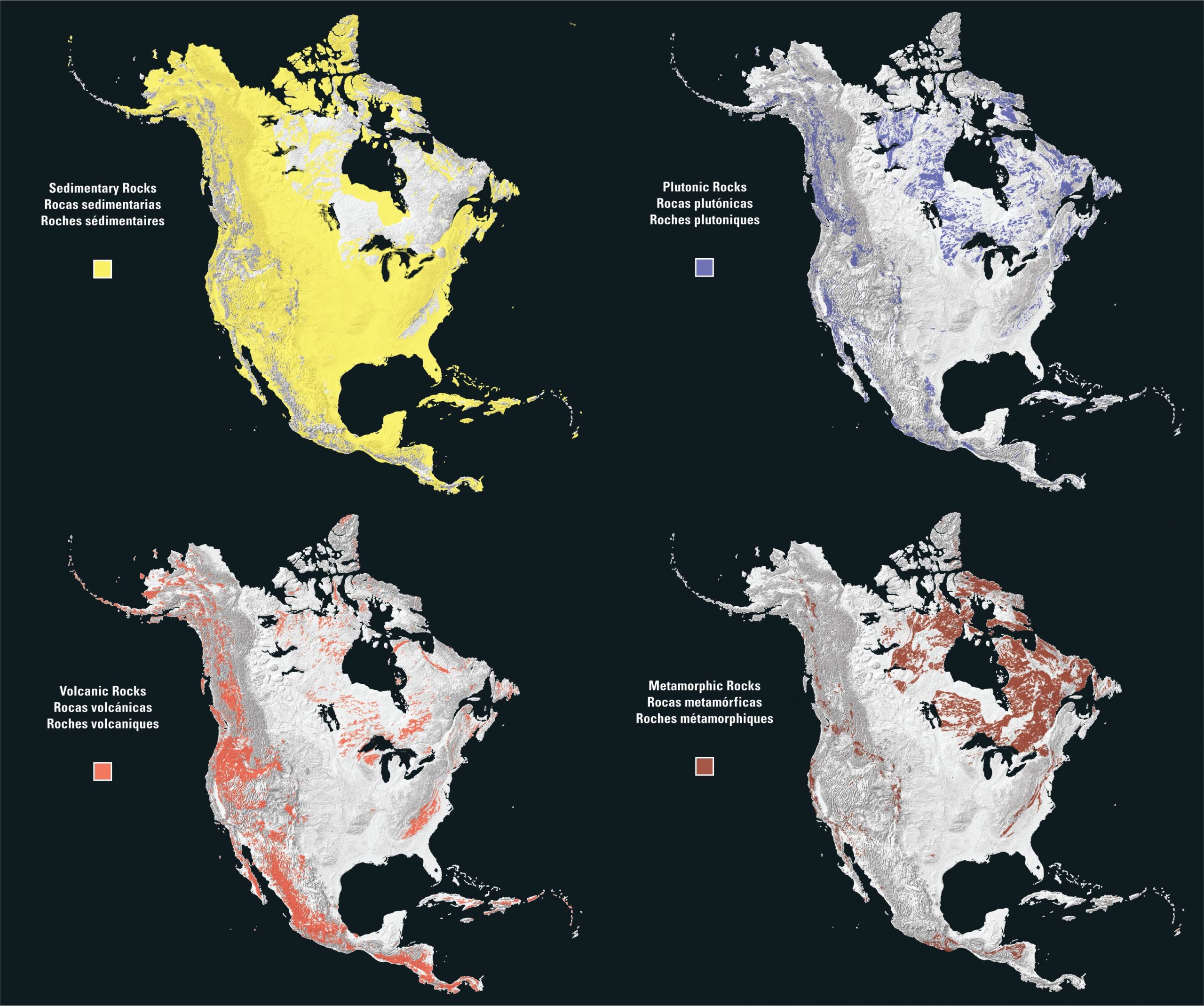
Another way to look at geologic provinces is to see the general distribution of rock types. Figure 10.8 shows how igneous (volcanic and plutonic), sedimentary, and metamorphic rocks are located throughout North America. Many sediments and sedimentary rocks are exposed at the surface. These materials typically cover the surface and overly older rocks. Sedimentary rocks exposed throughout North America are of all geologic ages and were often deposited in paleoenvironments different from what exists in the region today.
- Why do we consider plutonic and volcanic rocks separately when evaluating provinces? Hint: think about the cooling ages of the two types of igneous rocks.
- Why do we consider the youngest exposed crustal rocks when evaluating provinces (plutonic and/or metamorphic rocks)? Hint: Consider what processes are necessary to expose these deep rocks.
- Table 10.1 lists 10 major provinces of the United States. Use the map and key in Figures 10.9 and 10.10 to draw where these are located. You may be familiar with the names of some of these provinces, but feel free to search for their general locations to help you.
- How do the province boundaries you identified in Figure 10.7 (relief map) compare to the ones you identified in Figure 10.9 (geologic map)?
- Use all the maps provided (Figures 10.7 to 10.10), compile all the different features for each of the tectonic provinces listed in Table 10.1 to look at the characteristics of the ten provinces. Make sure to note observations in the “Topography Patterns” column, such as if the area is mountainous, or what direction are the mountains oriented, or if the hills are flat or gentle.
| Province | Dominant rock type | Youngest plutonic or metamorphic rock | Topographic Patterns | Geologic Structures |
| Sierra-Nevada | ||||
| Columbia Plateau | ||||
| Basin and Range | ||||
| Colorado Plateau | ||||
| Rocky Mountains | ||||
| Ozarks/Ouachita | ||||
| Great Plains | ||||
| Canadian Shield | ||||
| Coastal Plains | ||||
| Appalachians |
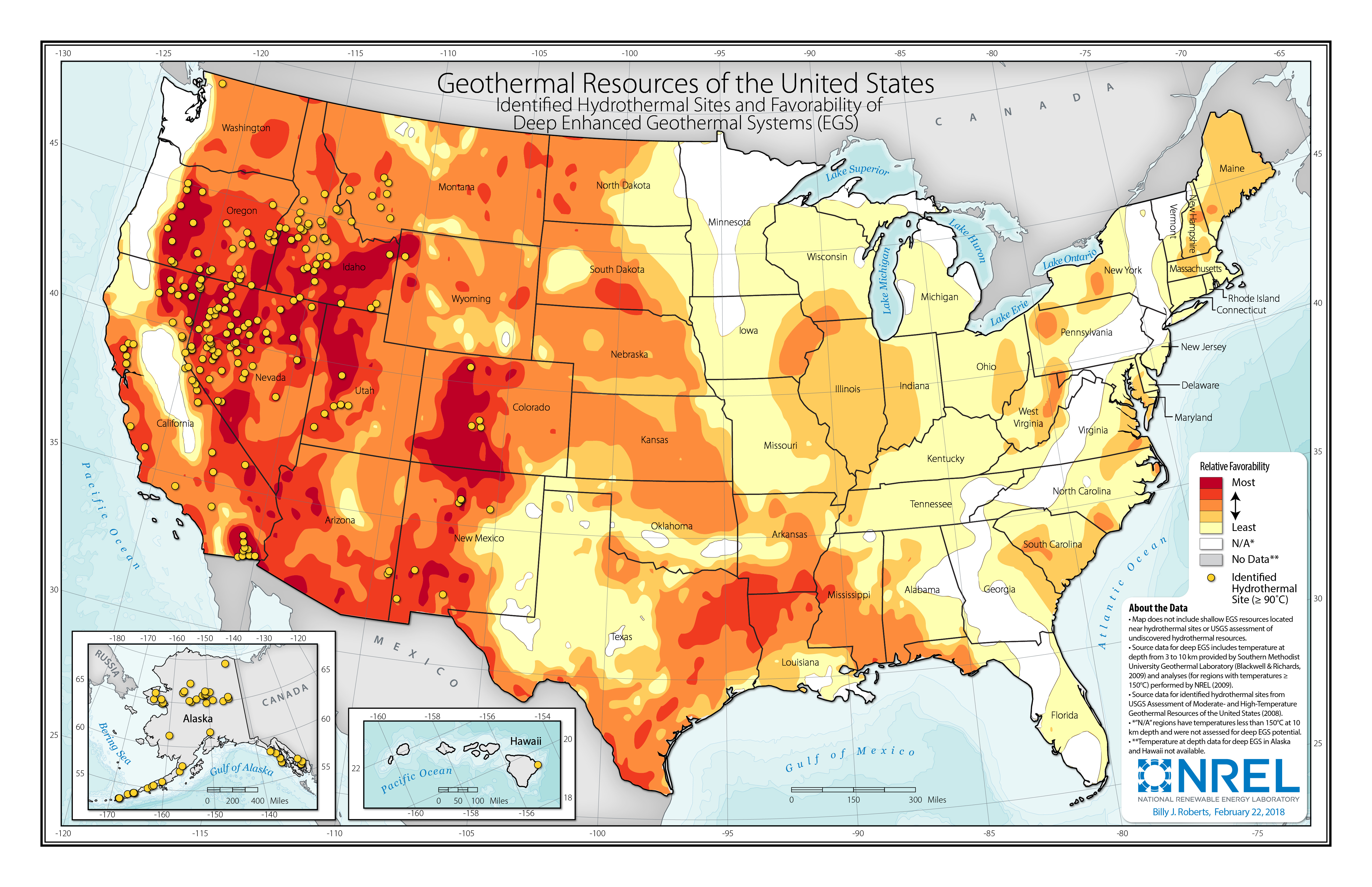
One major issue for society is potential sources of energy. Traditionally this has been coal and petroleum, as well as hydroelectric. Now, there is a push for alternative sources. Have you ever considered just using the temperature of the Earth as an energy source? This can be done using a heat pump to warm or cool a house. Since Vikings first landed in Iceland, they used geothermal energy for bathing, baking bread, and washing clothes. Now, nine out of ten homes in Iceland are powered by geothermal energy. In the United States, the Basin and Range province has great potential for geothermal energy (NREL).
- Critical Thinking: Figure 10.11 is a theoretical cross-section of the Basin and Range province. Why does the Basin and Range Province have a great potential for geothermal resources?
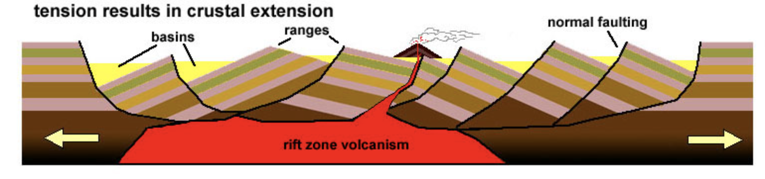
Figure 10.11 – Theoretical geologic structure of the Basin and Range Province. Image credit: from MiraCosta College, CC.
Exercise 10.3 – Northern New Jersey Map
The geology of northern New Jersey contains a record of the Appalachian Orogenies, including the assembly of Pangea and its subsequent breakup. You can print the geologic map (opens in a new tab) and cross-sections (opens in a new tab) on poster paper. Both maps contain descriptions of the bedrock lithology. The bedrock is either exposed at the surface or sits beneath loose, unconsolidated sediment. Alternatively, you can access digital versions of both maps from the USGS. Use the red arrows in the Map Preview to cycle between each map. The files available for download are on the right-hand side.
Part 1: Separating Geologic Provinces
- Observe the patterns of colors on the main bedrock map. Divide northern New Jersey into three different regions based on the colors and patterns on this map. Describe the three regions that you can identify using the colors on the map or ages of the rocks.
Part 2: Valley and Ridge Province
The Valley and Ridge Province formed as a result of deposition and slight deformation of sediments associated with the Taconic and Acadian Orogenies.
- Do the sedimentary rocks become older or younger as you move northwest? ___________
- On a regional scale, what does that tell you about the direction these rocks are dipping towards?
- On a regional scale, what does that tell you about the direction these rocks are dipping towards?
- The Basin and Range province of Nevada is formed through a series of normal faults where basins (valleys) are the hanging walls that dropped down relative to the ranges (mountains) on the footwall. Look at the structures that form the Valley and Ridge Province in New Jersey; how are they different from the Basin and Range Province of Nevada?
- For both locations, describe the types of plate boundaries or stresses that would cause these structures.
- For both locations, describe the types of plate boundaries or stresses that would cause these structures.
- The rock types give geologists clues to what the tectonic setting was. Limestones are typical examples of passive times with little to no tectonic activity. Sandstones, shales, and conglomerates are indicative of active tectonic margins, indicating uplift and then erosion of mountains. Table 10.2 contains a generalized stratigraphic column of the Valley and Ridge Province in northwestern New Jersey.
- In Table 10.2, identify the type of rock(s) that comprises each unit. Use terms limestone, shale, sandstone, conglomerate, and quartzite. Quartzite tells you the rock used to be sandstone. You can find all of this information on the 2nd map page.
- Indicate whether the area was an active or passive margin for each unit. Some units contain evidence for both.
- The Valley and Ridge Province contains sedimentary rocks derived from two Appalachian mountain-building events: the Taconic Orogeny and the Acadian Orogeny.
- In Table 10.2, label the rock units you think best represent when these orogenies were active. An orogeny can span more than one unit.
Table 10.2 – Worksheet for Exercise 10.3 Map Symbol Lithology Active or Passive Orogeny Dm Db Ds De Do Dp Dmn Dkc DSrd Sbv Sp Sb Ss Omr Omb Oj Ow Obu Obl OꞒa Ꞓl Ꞓh Yu Igneous and Metamorphic Grenville
Part 3: The Highlands Province
The New Jersey Highlands lie between the Valley and Ridge Province and the Newark Basin.
- What two types of rocks are the Highlands primarily made of? _________________________
- Are the igneous rocks primarily intrusive or extrusive? ________________
- Are the metamorphic rocks primarily high, medium, or low grade? ________________
- Most of the rocks in this region of New Jersey have the same age. What is it? (Hint: Look for the Mount Even Granite and the Hornblende granite of the Byram Intrusive Suite) _______________
- Critical Thinking: Come up with an explanation of how you get these different rocks forming simultaneously. (Hint: Think about the tectonic setting that could have done this)
- In the middle of the Highlands lie Silurian and Devonian sedimentary rocks (blue and purple colors). You can look at cross-section A-A’ to help.
- Do you think this isolated group of sedimentary rocks could be related to the Silurian and Devonian sedimentary rocks from the Valley and Ridge Province? (Hint: Look at some of the rock descriptions) _______________
- Explain your answer.
- If you thought they were similar, why aren’t these two areas connected?
- If you thought they were different, explain how you would get these two sets of sedimentary rocks deposited at the same time.
Many of the rocks in this region have an age that corresponds to the Grenville Orogeny and the assembly of the supercontinent called Rodinia. This orogeny is seen on many of the world’s continents, including North America, South America, Antarctica, Europe, and Africa, but because this event happened so long ago, much of the evidence has been altered or destroyed by tectonic processes.
You may have noticed there is no evidence of the Alleghenian Orogeny, which was the assembly of the Pangaea about 250 Ma. Any rocks from this orogeny have all been eroded in New Jersey, but much of the faulting and folding of rocks throughout the Valley and Ridge Province and the Highlands occurred during the Alleghenian Orogeny.
Part 4: The Newark Basin
The Newark Basin (Figure 10.12), which is part of the Piedmont Province of the eastern U.S. that extends from New York to Alabama, formed during the breakup of Pangaea during the Jurassic, which eventually led to the opening of the Atlantic Ocean.
- There is a stark transition from the Highlands Province to the Newark Basin.
- What is the name of the feature that separates the Newark Basin from the Highlands? ____________________
- What type of structure is this? Use the cross-sections to help. ____________________
- Critical Thinking: Look at the cross-sections associated with this map. Why are the sediment layers dipping to the NW?
- What types of igneous rocks would you expect to find in a rift valley? ____________________
- On Figure 10.12, find and mark these igneous rocks. (Hint: look for the Watchung Mountains)
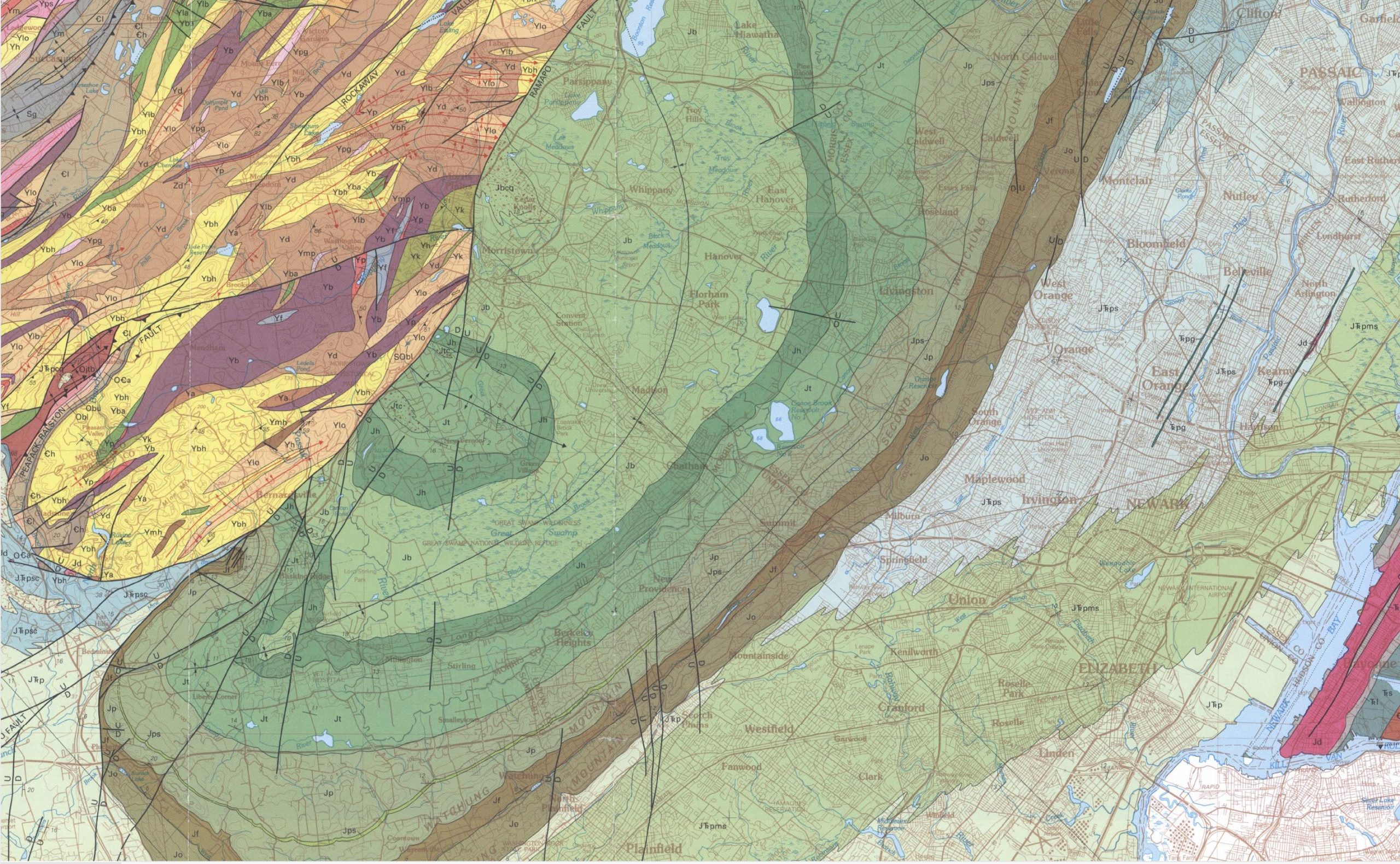
Figure 10.12 – Screenshot of the Newark Basin from the bedrock map of northern New Jersey. Image credit: USGS, Public Domain.
- On Figure 10.12, find and mark these igneous rocks. (Hint: look for the Watchung Mountains)
- Critical Thinking: Since this province was associated with rifting and tensional stress, you would not expect to find evidence of compressional stress in a divergent tectonic setting. But if you follow the Ramapo Fault closely, you will see anticlines and synclines connected to it perpendicularly. Explain why these compressional features are here.
Additional Information
Exercise Contributions
Daniel Hauptvogel, Virginia Sisson
References
Adolfssen, JS and Friedman, M, 2017, Review of the Danian vertebrate fauna of southern Scandinavia, Bulletin of the Geological Society of Denmark, 65, 1-23. doi: 10.37570/bdsg-2017-65-1
Desor, P.J.E., 1847, Sur le terrain Danien, nouvel étage de la craie. Bulletin de la Societé Géologique de France, 2 (4), 1779-182.
Golombek, M.P., and Phillips, R.J., 2010, Mars Tectonics in Planetary Tectonics, edited by Watters, T.R. and Schultz, R.A., Cambridge University Press, 181-232.
Some background info from https://whc.unesco.org/uploads/nominations/1416.pdf
Google Earth Locations

also called coccoliths are unicellular marine algae; they belong to the kingdom Protista. They have calcite scales that can form chalk.
limestone composed of shells of microscopic marine animals (foraminifera) and marine algae (coccoliths). Chalk is white or light gray, porous, permeable, soft and friable.
a chemical element with the symbol Ir and atomic number 77. Iridium concentrations in meteorites is much higher than any terrestrial rock. Thus, high concentrations of iridium are hypothesized to come from extraterrestrial sources.
